
Issue 17 | Summer 2018
Director's Corner
NOAA Embraces Community Modeling to Advance Weather Prediction
Brian Gross, Acting Director EMC
EMC is excited at the prospect of leveraging the modeling expertise in the numerical modeling community to improve NOAA guidance, forecasts, and other products and services.
The goal of this community effort is to evolve the Next Generation Global Prediction System (NGGPS) towards a national unified Earth system modeling framework for operations and research, to the mutual benefit of both. A Unified Forecasting System (UFS) will function on temporal scales from seasonal to sub-seasonal (S2S) on the order of months, down to short-term weather prediction on the order of hours to days. The UFS will also work across spatial scales, from global-scale predictions down to high-resolution, convection-resolving local/regional scales. Operational implementations of the UFS will be guided by the NWS’s National Centers for Environmental Prediction Environmental Modeling Center that leads the integration of research innovations into operational models.
The UFS is being developed by NOAA, other federal partners, and the broader research and academic community to build the best national modeling system possible. The definition of “community” is important, and not all community efforts will be identical. We are learning from prior and ongoing community modeling efforts (such as WRF, CESM, WW3, MOM6, etc.) and are adopting best practices that meet our specific situation.
NOAA recognizes that the UFS must support the needs of both operations and research. Without that linkage, the incentives will not be there for the research community to help make improvements that will benefit operational predictions, nor will operational innovations feed back into the models used for research. Building a community model involves both give and take from the operational and research sides. Lessons learned, such as from the Developmental Testbed Center (DTC), have shown us that the community will expect sufficient training, full support (including help desk), and vetting of scientific advances. Also, through NGGPS, the Joint Technology Transfer Initiative, and other coordinated programs, NOAA has opportunities for partners to engage through recurring Federal Funding Opportunities.
Working groups that span the specific modeling areas needed for the UFS began meeting in Spring 2017 to develop three-year plans that identify key partners and provide a set of milestones to benchmark progress. The collective input of those groups resulted in the publication of the first Strategic Implementation Plan (SIP) in November 2017. It is a dynamic process, and these working groups are working on updates to the SIP, with version 2 expected later this year.
To effectively coordinate the activities of the community partners, as well as to manage the collaborative projects of those partners described in the SIP, a robust governance structure is being put in place. Our governance approach is based a commitment by core development partners, informed practices, and community values. A UFS Steering Committee, comprised of both NOAA and non-NOAA members, is already working to provide technical guidance to the Working Groups. A Technical Oversight Board is about to be established to provide support for the programmatic elements across the NOAA Line Offices.
EMC is excited at the prospect of leveraging the modeling expertise in the numerical modeling community to improve NOAA guidance, forecasts, and other products and services. Better predictions can come from ensembles of model runs, better models can come from the assembled intellectual might of the entire modeling community. If you’d like to become engaged, please contact Tim Schneider at timothy.schneider@noaa.gov. While a UFS web portal is being developed, up to date information can be found on the NGGPS web pages.

Brian Gross, Acting Director EMC
Who's Who
Guoqing Ge
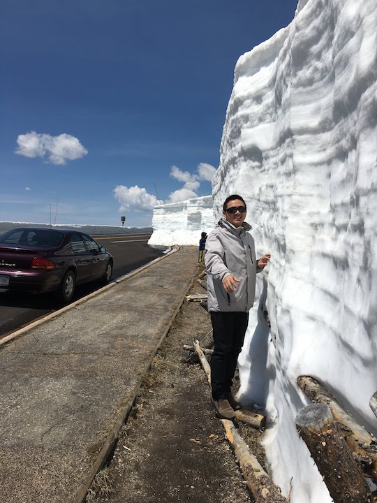
Guoqing Ge on Trail Ridge Road
“Read ten thousand books and travel ten thousand miles.” – A Chinese proverb and a favorite quote of Guoqing Ge who loves to read, would choose the superpower ability to fly, and has an ambitious travel bucket list that includes the North or South Pole and the Amazon rainforest. He has already traveled far from his hometown of Anqing China, an 800-year old city on the shores of the Yangtze River. Anqing is a 4-hour high-speed train ride to Shanghai, and almost 7,000 miles from Longmont, Colorado, where he moved with his wife and son in 2015.
Guoqing earned his Bachelor’s degree in Meteorology from Nanjing University in China, and a Master’s from Peking University. His Ph.D. on convective-scale data assimilation is from the University of Oklahoma, where he stayed on as a post-doc for a few years before joining GSD/CIRES as a research scientist in August 2015.
In July 2017, Guoqing joined the Data Assimilation task of the DTC. His role is to provide community user support for NOAA operational data assimilation system - Global Statistical Interpolation (GSI) and Ensemble Kalman Filter (EnKF) - and to conduct testing and evaluation of emerging data assimilation techniques. He says the best thing about his job is being well-connected with the data assimilation community and moving the latest research results into operations to make forecasts better.
Colorado’s beautiful mountain views, amazing weather and clouds, and outdoor activities inspired Guoqing to lose more than 30 pounds. He stays healthy by skiing, running, hiking, watching NBA games, and playing with his 10-year old son who likes many of the same things -- reading too. The most important thing he has learned is to take notes wherever possible, just as a Chinese Proverb says “the palest ink is better than the best memory.”
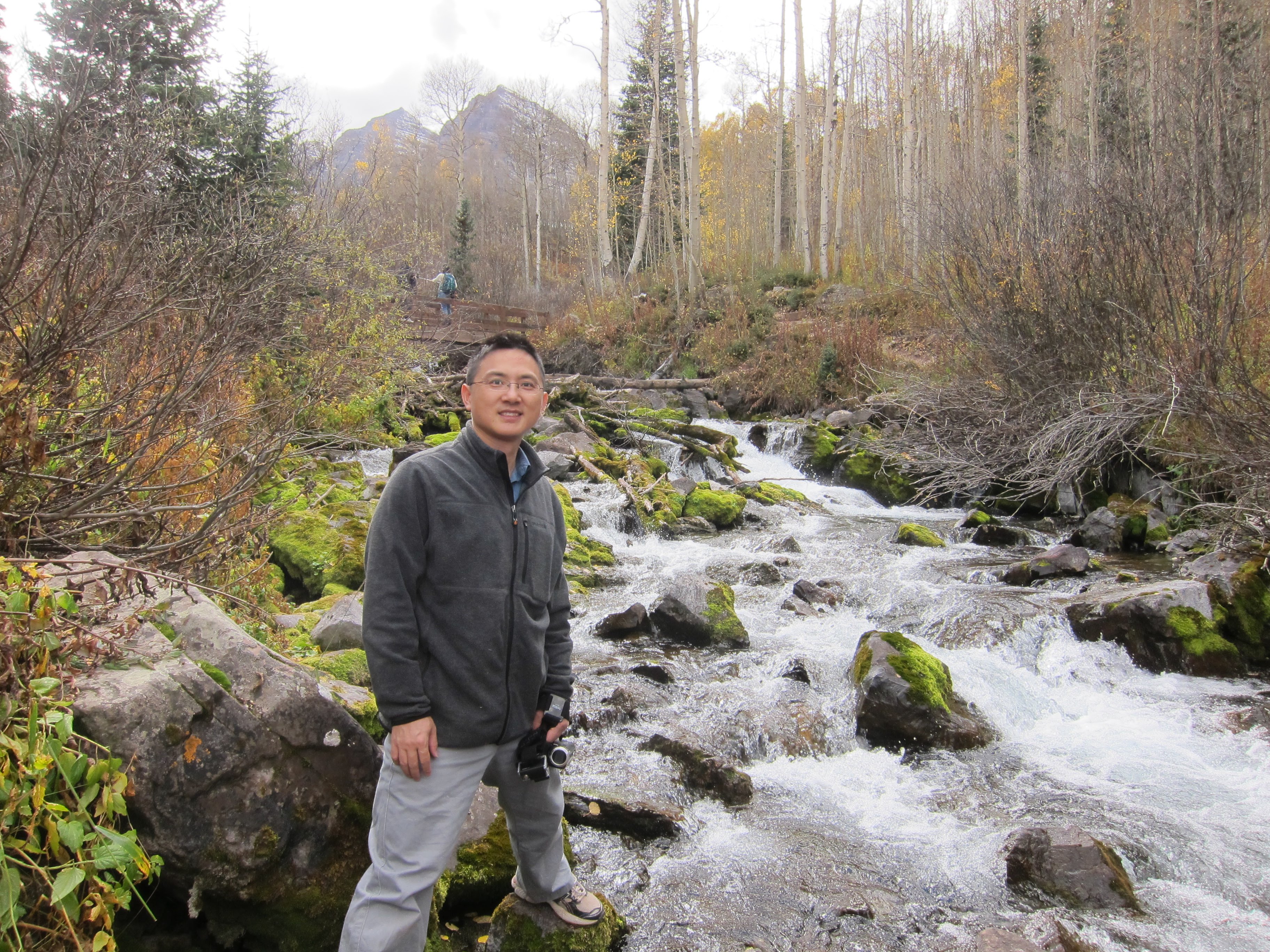
Guoqing Ge near mountain stream
Bridges to Operations
Tests Conducted at DTC Lead to Operational Implementation of Innovations in Physics and Data Assimilation in HWRF
The Hurricane Weather Research and Forecast system (HWRF) is one of NOAA’s operational models used to predict the track, intensity, and structure of tropical cyclones. Each winter, scientists at NOAA’s Environmental Modeling Center (EMC), the Developmental Testbed Center (DTC), and NOAA’s Hurricane Research Division (HRD) perform testing and evaluation (T&E) on possible changes to the HWRF physics schemes, dynamic core, and data assimilation system that have the potential to improve HWRF predictions. Many of these potential changes are innovations from the research community that have been added to branches within the HWRF code repository in the past year, with guidance from the DTC. These branches are then retrieved from the repository by EMC and DTC staff to perform annual T&E. This yearly upgrade cycle illustrates the seamless exchange of innovations from the research community to operational testing environments, which is facilitated by the code management and developer support provided by the DTC.
This year, the DTC effort focused on T&E of two potential upgrades to model physics. The first looked at upgrades to the Rapid Radiative Transfer Model for General Circulation Models (RRTMG) radiation scheme made available by John Henderson and Michael Iacono of Atmospheric and Environmental Research (AER) through the DTC Visitor Program. The second replaced the Scale-Aware Simplified Arakawa-Schubert (SASAS) cumulus scheme with the Grell-Freitas scheme, based on work by Georg Grell (NOAA’s Global Systems Division), Saulo Freitas (NASA), and Evelyn Grell (NOAA’s Physical Sciences Division) that was funded by the Hurricane Forecast Improvement Project (HFIP). The DTC also participated in several experiments led by HRD and EMC to determine the impact of assimilating additional data to improve the HWRF initial conditions.
Each of these potential upgrades was first tested individually by running retrospective HWRF forecasts on a subset of tropical cyclones from the past three years in the North Atlantic ocean. For these initial tests, EMC selected sixteen storms that provided a mixture of storm intensities, storm motion directions, and previous operational model performance. For the RRTMG radiation scheme upgrades, the DTC ran nine of the sixteen storms before EMC staff decided the forecast improvements (~4% for both track and intensity) merited including the changes in the 2018 version of HWRF. Results from the Grell-Freitas experiment indicated the scheme was not yet ready for operational implementation. However, the results are informing additional changes to the code by the developers, who are working with DTC and EMC staff to test an improved version of their scheme later this summer. For the data addition experiment, the DTC ran 2–3 storms for each additional data type, which helped EMC determine that wind data from the Stepped Frequency Microwave Radiometer and inner-core dropsondes should be assimilated into HWRF in 2018.
Once the 2018 configuration of HWRF is finalized, DTC and EMC will work together to merge the final version of the code back to the HWRF trunk. This step will enable researchers to add additional innovations to the latest version of the code, ensuring that any scientific results are directly applicable to the operational HWRF, which will position the community well for next year’s HWRF pre-implementation tests. With additional opportunities for transition of research to operations in upcoming versions of the model, DTC staff look forward to continuing to lend their expertise in code management, developer support and T&E to the community!
Visitors
Impact of Vertical Advection Schemes of the Hydrometeors on the Simulated Hurricane Structure and Intensity
Visitor: Shaowu Bao
Advection is a computationally expensive process in Numerical Weather Prediction (NWP) models. Therefore, time-sensitive operational forecast models sometimes sum up the hydrometeors, including cloud water, rainwater, ice and snow, prior to calling the advection scheme. For this configuration, the model only needs to calculate the advection of the total condensate. However, the impact of such a time-saving technique has not been systematically evaluated. With the release of HWRF 3.9a, a version of the operational HWRF microphysics scheme with separate hydrometeor advection became available to the research community, providing an excellent opportunity to study how simulated hurricane structures differ according to the advection schemes they use. As a DTC Visitor, Shaowu Bao evaluated the impact of vertical advection schemes of the hydrometeors on the simulated hurricane structure and intensity in the Hurricane Weather Research and Forecasting (HWRF) model.
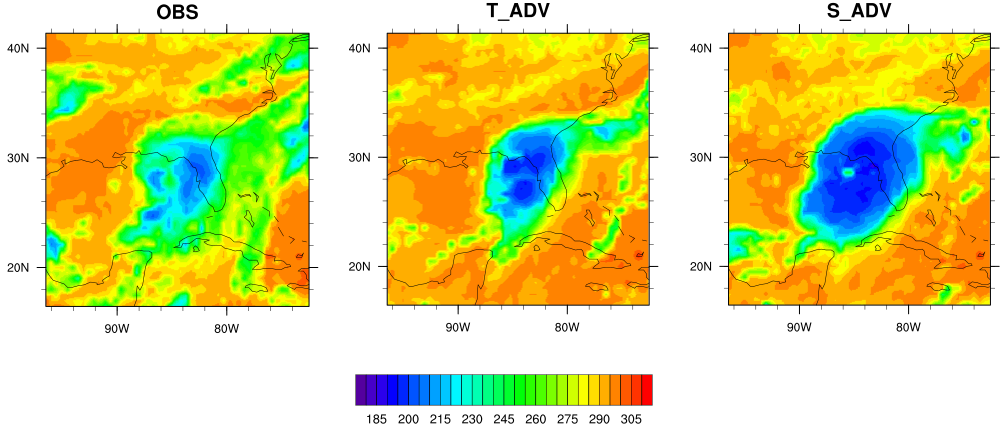
Hurricanes Matthew (2016) Hermine (2016) and Jimena (2015) were simulated using the operational HWRF 2017 with the advection of total condensate (hereinafter T_ADV) and that of separate hydrometeors (hereinafter S_ADV). Their results were then compared against the infrared (IR) brightness temperature images data from NOAA's Geostationary Operational Environmental Satellite GOES 13.
The most distinct difference between the T_ADV and S_ADV results was the simulated storm size. In Figure 1, a deep blue IR brightness temperature indicates a cold cloud top and red-brown identifies the warm surface of the Earth with no-cloud or fewer cloud conditions. T_ADV and S_ADV produced similar storm locations and shapes that both matched the observed. However, S_ADV produced cloud coverage that was noticeably larger than that produced by T_ADV.
Our hypothesis suggests the total condensate advection in T_ADV overestimates the upward advection of rainwater and underestimates that of cloud water. By correcting this problem, the S_ADV scheme transports more cloud water upward than T_ADV, leading to more diabatic heating from condensation and more angular momentum to be imported into the hurricane vortex. This causes the larger size of hurricanes simulated by S_ADV than those by T_ADV. Our results of the angular momentum (Figure 2) and other analysis confirmed this hypothesis.
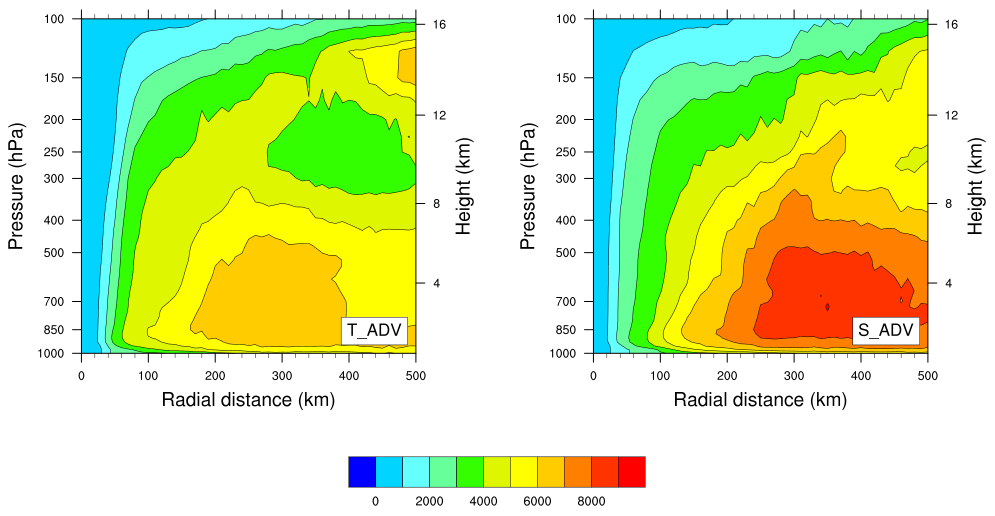
Although in theory the separate advection of hydrometeors in S_ADV is more realistic than the advection of total condensate in T_ADV, this evaluation showed that S_ADV simulated much larger storms than T_ADV and the observed hurricanes, and therefore degraded the HWRF performance. Future work is needed to identify the adjustments in the model that may have masked the error related to the total condensate advection, so that the separate hydrometeors advection can achieve better forecast performance.
Shaowu found that the two weeks spent at NCAR collaborating with DTC scientists was a very pleasant and productive experience. He wants to especially thank Ligia Bernardet, Evan Kalina, Mrinal Biswas, Greg Thompson and Louisa Nance, as well as Kathryn Newman. Without their help and support setting up the model, providing input data, and analyzing the results, this project was impossible to complete.

Shaowu Bao
Community Connections
2018 DTC Community Unified Forecast System Test Plans and Metrics Workshop
July 30 - August 1, 2018
The 2018 DTC Community Unified Forecast System Test Plan and Metrics Workshop was held at NOAA’s National Center for Weather and Climate Prediction (NCEP) on July 30 - August 1, 2018. The major goal of this workshop was to work towards a community test plan with common validation and verification metrics for the emerging Unified Forecast System (UFS). The plan will serve as a guide for the Numerical Weather Prediction (NWP) community for testing and evaluating new developments for the UFS models and components by comparison of both historical and real-time forecasts using observations and analyses, through standardized hierarchical testing.
The workshop organization was led by the Developmental Testbed Center (DTC), and the organizing committee was representative of various aspects of the NWP verification and validation (V&V) enterprise, including voices from those working on research, development, transitions, and operations. The membership of the organizing committee was:
-
Curtis Alexander - NOAA/Earth Systems Research Laboratory Global Systems Division (GSD)
-
Ligia Bernardet - CU/Cooperative Institute for Research in Environmental Studies (CIRES) at NOAA/GSD and DTC
-
Tara Jensen - National Center for Atmospheric Research (NCAR) and DTC
-
Jim Kinter - George Mason University/Center for Ocean-Land-Atmosphere Studies (COLA)
-
Sherrie Morris (NOAA Office of Science and Technology Integration (OSTI)
-
Jason Levit (NOAA/NCEP/Environmental Modeling Center (EMC)
-
Ryan Torn (State University of New York at Albany)
-
Ivanka Stajner (NOAA OSTI on detail to NOAA/NCEP/EMC)
The workshop was attended by approximately 100 participants, cross-cutting through various sectors of the V&V community, including international (Taiwan Central Weather Bureau and European Center for Medium-range Weather Forecasting (ECMWF), universities, NASA, NOAA National Environmental Satellite, Data, and Information Service (NESDIS), research laboratories, Office of the Federal Coordinator for Meteorological Services and Supporting Research, National Weather Service, testbeds, Navy, U.S. Air Force, and the private sector.
The workshop had a mix of presentations, discussion periods, and working sessions in which participants contributed to the three topic-based breakout sessions: test plans, metrics, and hierarchical testing. Metrics for all spatial and temporal scales for numerical weather prediction models and emerging topics such as the verification of convective allowing models, coupled earth system models, and ensemble systems were discussed.
The last activity in the workshop was a summary of the working sessions’ discussions by their leads, which was presented to workshop participants and members of the UFS Strategic Implementation Plan (SIP) meeting. A report on the progress made during the workshop will be available in the next few months.
A link to the workshop page is here: 2018 DTC Community Unified Forecast SystemTest Plans and Metrics Workshop
Did you know?
The Next Generation Global Prediction System
The Next Generation Global Prediction System (NGGPS) multi-year Strategic Implementation Plan (SIP) connects federal and academic experts in the numerical weather prediction community to support the end-to-end functionality of the National Centers for Environmental Prediction (NCEP) Production Suite. The goal of the SIP is to help evolve the NGGPS into a Unified Forecast System (UFS) for operations and research.
-
The SIP governance includes UFS Working Groups who represent the essential science, technical, and design capacity of the UFS and span the community of expertise needed to support it.
-
UFS Working Groups consist of subject matter experts across NOAA line offices and laboratories, Navy, NASA, NCAR, and Universities.
-
The SIP Working Groups are always seeking members from the research and development community.
For more information on the SIP process, please visit: https://www.weather.gov/sti/stimodeling_nggps_implementation
Contact
303.497.8921
dtcenter@ucar.edu
Addresses
mailing:
PO Box 3000
Boulder, CO 80307-3000
Shipping:
3090 Center Green Dr.
Boulder, CO 80301
Follow Us
Copyright © 2024. All rights reserved.