The Earth Prediction Innovation Center (EPIC) provides user support and feature enhancements for select Unified Forecast System (UFS) applications, models, and components. To request new UFS features or enhancements, post a request on the ufs-community GitHub Discussions page under Enhancement. View the posting guidelines for details on what information to include. For requests specific to one of EPIC’s supported repositories, community members can post directly in the Enhancement category for that repository: the Short-Range Weather (SRW) Application, the Land Data Assimilation (DA) System, the UFS Weather Model, and the Unified Post Processor. Any lingering questions? Just email us at support.epic@noaa.gov!
Did you know?
Events and Opportunities
Autumn 2023
Upcoming Events
Attending AGU or AMS and interested in learning more about what the DTC staff are up to? Check out these presentations!
2023 AGU Annual Meeting
2024 AMS Annual Meeting
Internship Opportunities
The NCAR Earth System Science Internship (NESSI), hosted by NCAR Education, Engagement & Early-Career Development (EdEC), offers students interested in the Earth system sciences an opportunity to conduct research with NCAR scientists from across all labs on a wide range of topics including but not limited to atmospheric science, computational science, engineering, and solar & space physics. The program is designed to support students and promote Earth system science through research, mentoring, and community building.
NESSI is accepting applications for the 2024 Summer internships through January 6, 2024. Find more details on the FAQ page.
Significant Opportunities in Atmospheric Research and Science (SOARS) is an undergraduate to graduate program built around a summer research internship, mentoring by top scientists and engineers, and a supportive learning community. In addition to the summer internship, SOARS includes year-round support, funding to attend conferences and last-dollar tuition scholarships. Successful protégés are eligible to participate in the program for up to four years. SOARS is now accepting applications for its 2024 program through February 1, 2024. Apply here.
Internship Opportunity
Summer 2023
The Lapenta internship invites undergraduate (sophomore and junior) as well as graduate students from all STEM disciplines (marine science, atmospheric science, engineering, social science, applied math, etc) to participate in 10-week (early June to mid August) projects that span all five line offices and the Office of Marine and Aviation Operations. These projects are high-impact, short-term research-to-operations (R2O) efforts where students learn coding and networking side-by-side with many government employees. The application period starts on October 1, 2023 and closes on January 3, 2024. FAQ sessions will be held on September 27, October 16, November 3, and December 18. Interns will be chosen by late February and, depending on the project/mentor and intern needs, projects will be undertaken virtually or in person at locations such as College Park, MD, Miami, FL, Boulder, CO and Seattle, WA. Completion of this internship will qualify each student for direct-hire by NOAA, along with valuable experience preparing them for future jobs in the private, academic, and public sectors. Visit the Lapenta program website and application site to learn more.
METplus Advanced Training Series Focuses on High Impact Events and Subseasonal to Seasonal Prediction
Spring 2023
The METplus team offered three sessions of an advanced training series during Spring 2023 and plans to add three to four new sessions during Fall 2023. The intent was to extend beyond the Basic Training Series provided during the winter and spring of 2021/2022. The recorded Basic series and report about the sessions can be found at METplus Training Series.
The three Spring sessions focused on evaluation of the Unified Forecast System (UFS) subseasonal to season (S2S) forecast prototypes. Session 1 demonstrated how to run METplus on Amazon Web Services using the prototype data stored on the NOAA Open Data Dissemination (NODD) service. Session 2 focused on demonstrating the use of METplus for S2S at the Climate Prediction Center (CPC) and community contributed diagnostics. Session 3 provided examples of evaluating marine and cryosphere predictions utilizing use-cases within the METplus wrappers GitHub repository. The recorded sessions can be found at METplus Advanced Training Series. The sessions in the fall will include examples of evaluating ensembles and using the python-embedding capability to read in unique datasets. Sessions will also be offered that highlight new enhancements to evaluate more components of a fully coupled Earth system model for prediction of subseasonal, seasonal, and high impact events like wildfires, tropical cyclones, and flash floods. If you have not already signed up, visit the Registration page to sign up for the fall session.
Contributed by Tara Jensen, John Opatz, and Molly Smith

DTC is involved in upcoming events
When: July 17-21 2023
Where: Madison, Wisconsin and virtual.
Registration: See the link above to sign up.
When: July 24-28, 2023
Where: Boulder, CO and virtual
Registration is open. See link for more details about #UIFCW2023.
➤ Event: CCPP Visioning Workshop
When: August 15-17, 2023
Where: Virtual
Registration: See the link above to sign up.
➤ Event: METplus Advanced Training Series
When: April 19 2023 to Oct 31 2023 | bi-weekly | 9:00am MT, 11:00am ET (with a summer break; the schedule for the second 5 sessions will be released in July.)
Where: Virtual
Registration: See the link for details to sign up late as the training is underway.
DYK that there is a DTC Community on Twitter https://twitter.com/DTC_Community that YSK
DTC will be involved in a number of upcoming events
Winter 2023
Did you know?
➤ Upcoming Event: The First UFS Physics Workshop
When: May 16-18, 2023
Location: Boulder, CO, TBD Soon (to be held at either NOAA/ESRL or NCAR).
Registration is open: See the link above to sign up.
The UFS Physics Working Group is organizing the first in what is envisioned to be an annual event to discuss the latest advances in research and development that should be considered in further UFS physics development and implementation to address research and operation needs of the UFS community. The focus for the first workshop, which will consist of presentations and breakout discussions, will be cloud microphysics.
➤ Upcoming Event: AMS 32nd Conference on Weather Analysis and Forecasting / 28th Conference on Numerical Weather Prediction / 20th Conference on Mesoscale Processes
When: 17-21 July 2023
Where: Madison, Wisconsin and online.
Abstract Submission Deadline: 17 March 2023 for all three conferences <--- New date
➤ Upcoming Event: The Unifying Innovations in Forecasting Capabilities Workshop (UIFCW), a UFS Collaboration Powered by EPIC
When: Monday, July 24, 2023 – Friday, July 28, 2023
Where: Boulder, CO
Objective: To understand how academia, industry, and operations work together to enhance The Unified Forecast System and leverage this knowledge to accelerate contributions and measure their success.
Registration is open. Abstract Submissions will open in March and close in May 2023.
See link for more details about #UIFCW2023.
Registration is open for the 2023 Lapenta Internship
Autumn 2022
NOAA is offering paid summer internships, named the 2023 Lapenta Internship, targeted towards current 2nd and 3rd-year undergraduate and enrolled graduate students to work in areas that will provide robust research and/or operational experience to prepare them for further study in NOAA fields, for application to fellowships, or for the NOAA-mission workforce.
Projects may be focused on research areas or the development of operational products such as decision support tools, climate and weather forecast models, population dynamics of fish populations, ecosystem modeling, hydrology, ocean circulation models, unmanned systems (both in air and underwater), data analysis methodologies, social science, and strategies to communicate climate and weather information pertaining to NOAA's mission to the public and to stakeholders. Overall, students will focus on areas that will meet the future needs of NOAA’s ever-broadening user community and address immediate challenges across a diverse spectrum from the sun to the bottom of our oceans. This internship program enables the many NOAA agencies to target the skills needed to fulfill their specific mission needs.
The application period for the 2023 Lapenta Internship will be open from Oct 1, 2022 to Jan 5, 2023 (about one extra week will be allowed for processing of recommendation letters). The 2023 Lapenta Internship will run from June 5, 2023 to August 11, 2023.
Eligibility information:
- Must be enrolled in an undergraduate (sophomore and junior status only) or graduate degree program, and be a U.S. Citizen willing to undergo a security background check. US citizenship must be in hand by Jan 1, 2023.
- Students from all STEM majors relevant to NOAA's mission will be considered.
- NOAA’s Diversity and Inclusion Strategic Plan applies, where members of groups underrepresented in the sciences are strongly encouraged to apply.
For more information, visit the 2023 Lapenta internship website.

New UCAR and WPO fellowships for PhDs
Autumn 2022
UCAR’s Cooperative Programs for the Advancement of Earth System Science (CPAESS) is excited to announce the launch of a new fellowship with NOAA's Weather Program Office (WPO): the WPO Innovation for Next Generation Scientists (WINGS) Dissertation Fellowship. The WINGS Fellowship is designed for Ph.D. candidates who have completed their required coursework, and are in the beginning stages of writing a dissertation. Fellows will work with their academic advisor and a mentor recommended by WPO and CPAESS. This inaugural award year will focus on research relevant to NOAA's Earth Prediction Innovation Center (EPIC) Program mission. The Application Deadline is January 27, 2023.
Potential topics for the fellowship this year can focus on one or more areas of scientific and/or technical importance shared by UCAR and EPIC, including:
- Data Assimilation
- Atmospheric Physics
- Systems Architecture (coupling, workflow, continuous integration and development)
- Machine Learning/Artificial Intelligence
- Software Engineering to advance numerical weather prediction
For more information, visit the Weather Program Office (WPO) Innovation for Next Generation Scientists (WINGS) Dissertation Fellowship webpage.
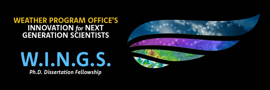
Weather Program Office (WPO) Innovation for Next Generation Scientists (WINGS) Dissertation Fellowship. Gain real-world doctoral experience applying expertise in your field of study to weather model development with the Earth Prediction Innovation Center (EPIC).
The METexpress Visualization Suite
Summer 2022
A major advancement of the Unified Forecast System Research-to-Operations (UFS-R2O) project has been the implementation of the DTC’s advanced Model Evaluation Tools (METplus) as a unified verification system for community model-development efforts. A community verification tool is important for this sort of decentralized development endeavor, as it gives all participants a common framework for evidence-based decision making when transitioning these models to operations. METplus processes numerical weather prediction output and matched “truth data” (which includes observations, analyses, tropical cyclone tracks, etc.) into a standardized format, which is then stored in a relational or document database. As a way to retrieve and visualize this stored data, the NOAA Global Systems Laboratory (GSL) and the DTC have collaboratively developed METexpress, a lightweight, quick-start visualization suite, a component of the overall METplus package. METexpress comprises eight individual apps, each designed to verify a particular meteorological facet, and features an intuitive interface with which users can quickly produce interactive graphs of common plot types.
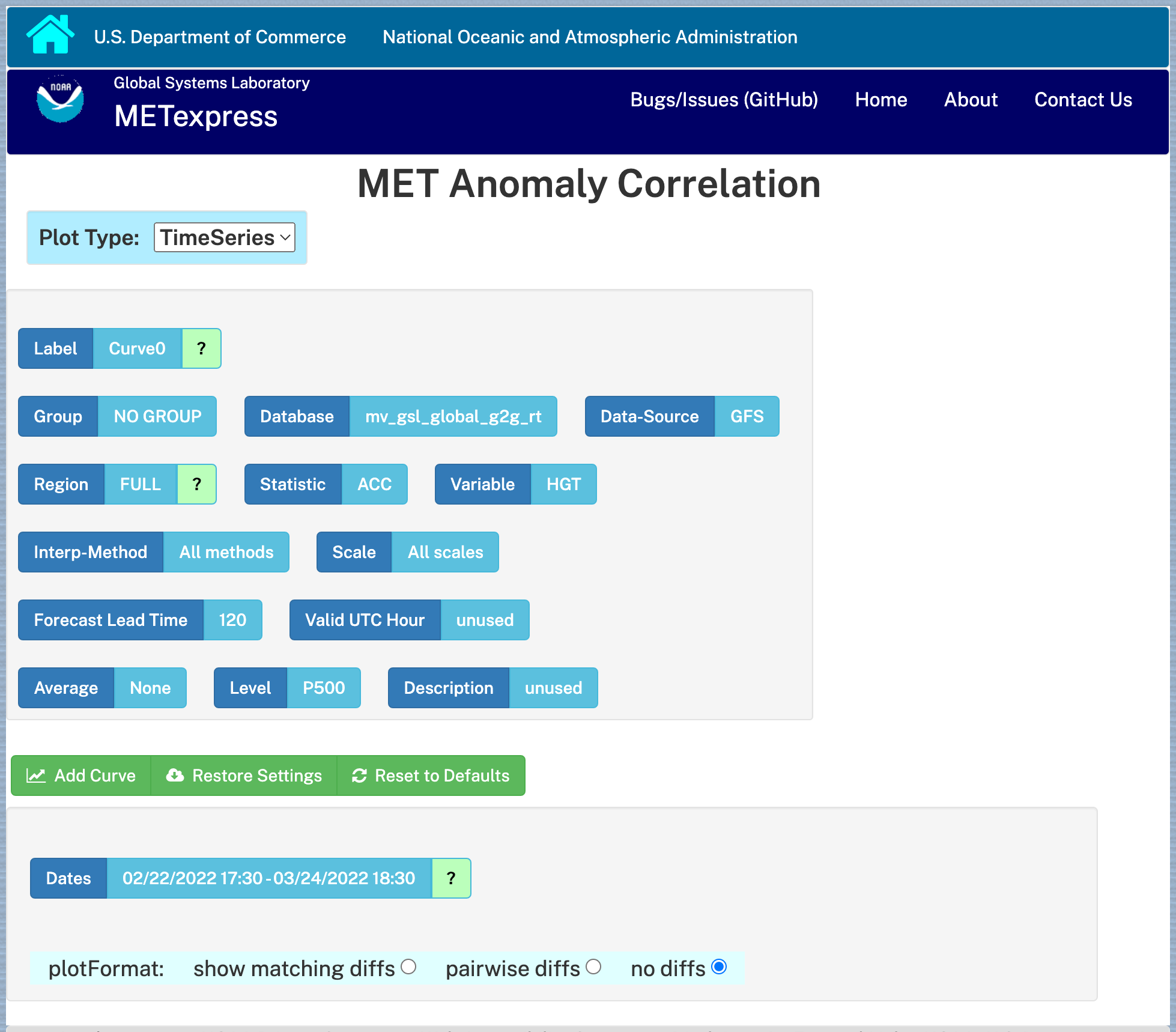
The METexpress user interface.
The applications currently included are:
- MET Upper Air–Displays scalar and vector statistics for upper air fields on isobaric levels.
- MET Anomaly Correlation–Displays anomaly scalar and vector statistics.
- MET Surface–Displays scalar and vector statistics for surface fields on surface levels.
- MET Air Quality–Displays scalar and contingency table statistics for air quality fields on surface levels.
- MET Ensemble–Displays ensemble and probabilistic statistics for various fields.
- MET Precipitation–Displays scalar, contingency table, EV, and FSS statistics for precipitation fields.
- MET Cyclone–Displays statistics specific to tropical and extratropical cyclones. Users can examine specific ocean basins, years, and storms.
- MET Objects–Displays MODE statistics for various fields.
These applications are able to present METplus data in numerous plot types, including timeseries (time on x-axis), profile (vertical level on y-axis), dieoff (forecast lead time on x-axis), valid time (hour of the day on x-axis), threshold (threshold on x-axis), grid scale (grid scale on x-axis), year-to-year plots (yearly averaged timeseries), histogram, ensemble histogram, reliability curve, ROC diagram, performance diagram, and contour.
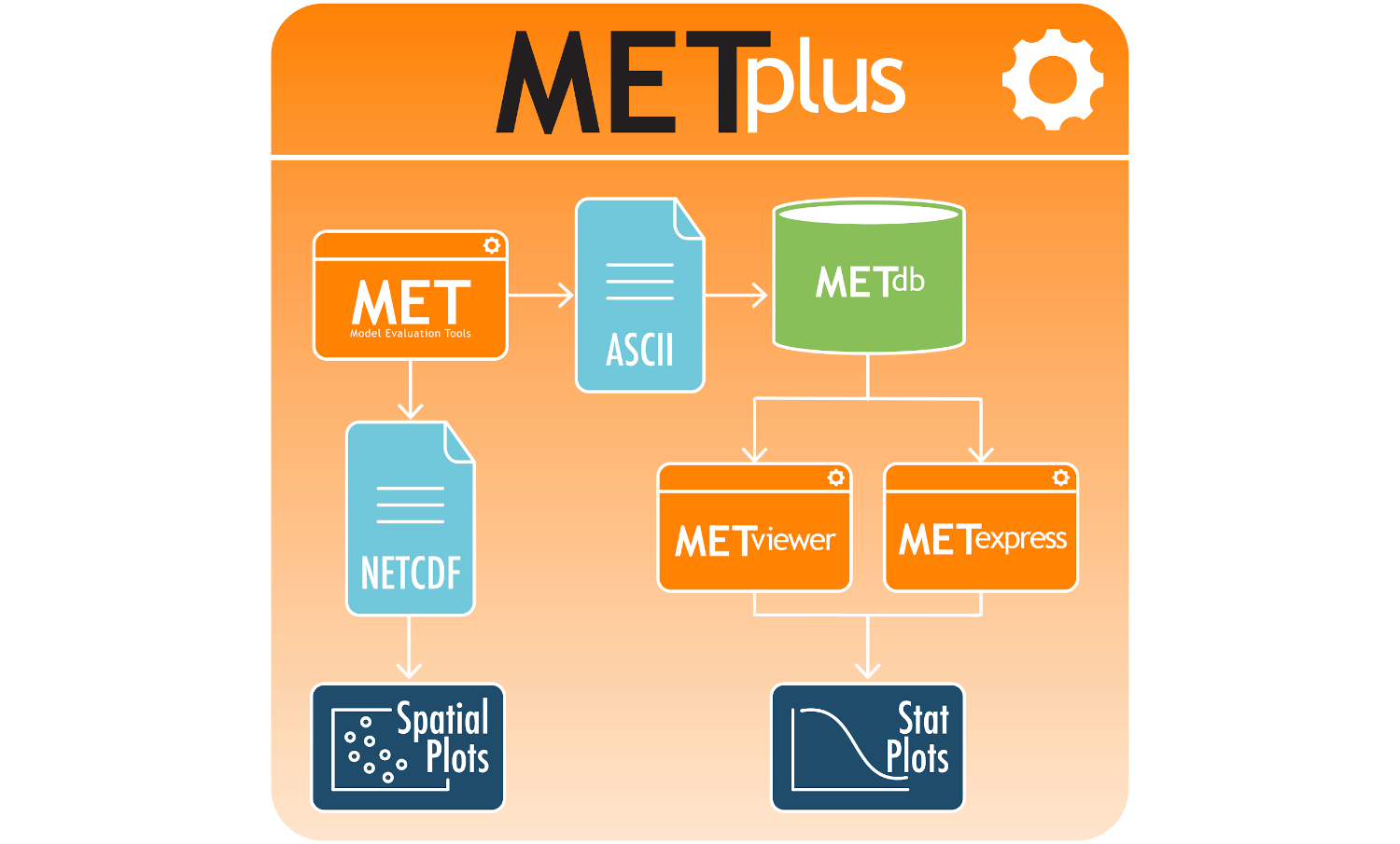
METexpress is a component of the overall METplus package.
METexpress has transitioned to operations within the NWS Environmental Modeling Center (EMC) (https://metexpress.nws.noaa.gov), and with NOAA GSL’s in-house model developers (https://gsl.noaa.gov/mats). METexpress, like the rest of METplus, is open source, and our hope is that, as more features are added, its use continues to expand amongst the UFS-R2O community, and to other public- and private-sector entities, aiding the development of new, next-generation models.
For more information about METexpress, please visit https://dtcenter.org/community-code/metexpress or email mats.gsl@noaa.gov.
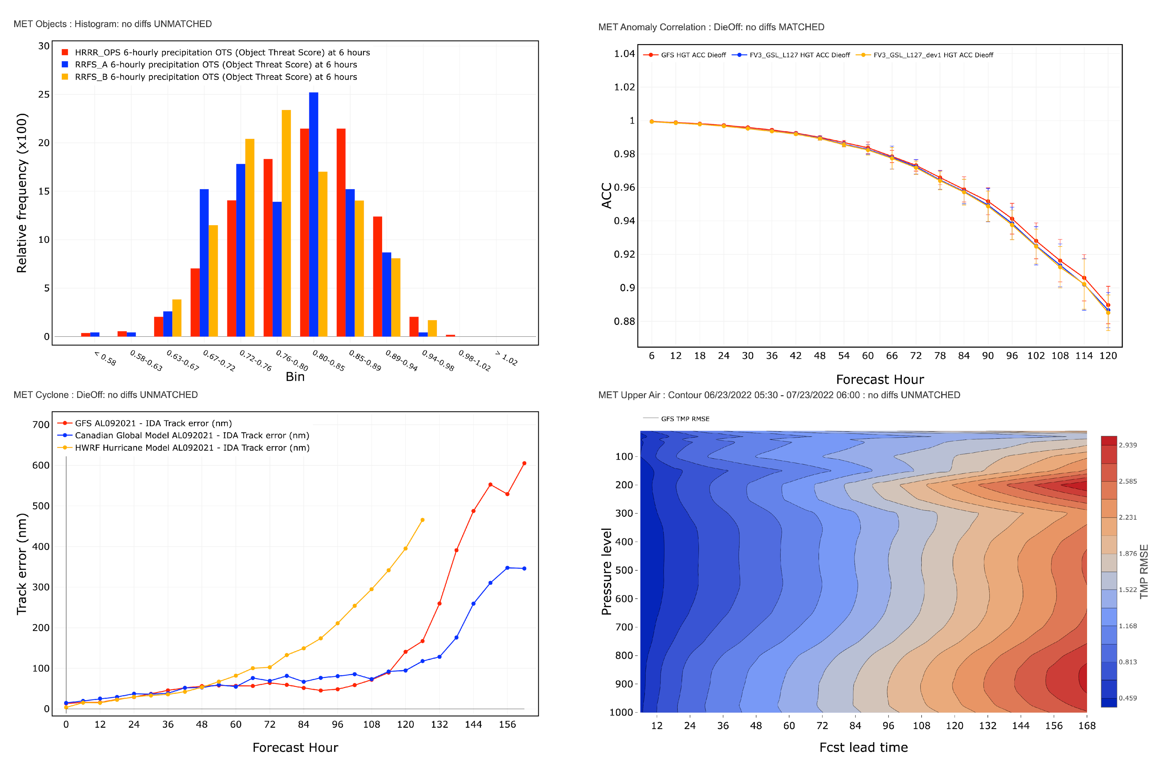
Sample METexpress plots.
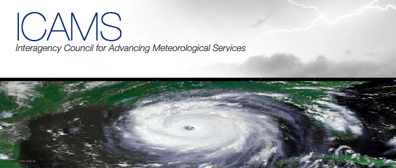
New US Council for Interagency Coordination of Meteorological Service
Spring 2022
In April 2017, the President signed into law the Weather Research and Forecasting Innovation Act. This Act required establishing an Interagency Committee for Advancing Weather Services -- The Interagency Council for Advancing Meteorological Services (ICAMS) meets this requirement. ICAMS serves to improve coordination of relevant weather research and forecast innovation activities across the United States Government. Sixteen various Departments and Agencies comprise ICAMS, including NSF, NOAA under the DOC and NASA.
Better coordination among federal agencies and expanded partnerships with the weather enterprise will foster improved weather, water, and climate information for the American public, ensuring US leadership in the world in meteorological services via an Earth-system approach, providing information that directly benefits society. ICAMS, chartered July 2020, was championed by US government administrative leaders, at that time, Dr. Kelvin Droegemeier and Dr. Neil Jacobs. Note that ICAMS replaces the former Office of the Federal Coordinator for Meteorology and the former National Earth System Prediction Capability with a section on the ICAMS resource webpage that bridges the past and present.
The work of the ICAMS is organized under four primary committees:
- Committee on Observational Systems – Coordinates all relevant land/air/ocean/space-based observation systems and associated data capabilities for meteorological research and services.
- Committee on Cyber, Facilities, and Infrastructure – Coordinates all relevant computing, data, networking, and security elements for operations and research.
- Committee on Services – Coordinates meteorological services encompassing weather, climate, hydrological, ocean, and related environmental services. Services include all relevant activities that provide value to society whether over land, at sea or in the air.
- Committee on Research and Innovation – Coordinates an Earth system approach to advance meteorological services including definition of research topics, community engagement, coordination among research organizations, engagement of multi-sector enterprise to maximize technological innovation, creation of new modalities/processes/efficiencies, building collaborations, and pursuing frontier capabilities.
DTC Visitor Program accepting applications
Winter 2022
Despite the challenges of COVID, the DTC Visitor Program is thriving. With the incremental opening of NCAR facilities, some visitors have been working on site, while others have been collaborating with DTC staff remotely. We invite researchers to apply to the program as an opportunity to collaborate with us on a diverse range of exciting projects. Our program has hosted visitors who have made cutting-edge enhancements to DTC software and tools, model improvements, innovated verification methodologies, and tested and evaluated products. To learn more about our program and how to apply, please read our recently updated Announcement of Opportunity.
See past Visitor Program articles that describe projects that supported operational weather prediction centers with advances in operational weather forecasting, and those that provided researchers with NWP codes that represent the latest advances in technology, including cloud computing tools and containers.
For more information about the visitor program, please go to: https://dtcenter.org/visitor-program

"I’ve had the pleasure of working under the DTC Visitor’s Program and the experiences provided me with wonderful opportunities to work with those at the forefront of numerical weather prediction activities, from the theoretical to the applied. I found that the most exciting and rewarding work came as a result of my coordinating ahead of time with potential beneficiaries of my work, located throughout NCAR, NOAA Boulder, and NCEP. As I look back on my DTC experiences from the perspective of someone nearing the end of his career, I find myself thinking that the activities helped me to explore new ideas, generally serving as a platform to launch off on continued ventures after the visit". --Don Morton, Boreal Scientific Computing
METplus Tutorial Series -- November 2021 to May 2022
Autumn 2021
METplus will be launching a Tutorial Series on Tuesday, November 30, 2021. Participants can join METplus trainers weekly for one-hour online sessions where presentations by subject matter experts will be woven throughout the hands-on training.
Visit the METplus Training Series website to obtain more information and to register.
NOAA HPCs Hera and Jet will be used for NOAA participants that have access to these platforms. Amazon Web Services Cloud computing will be used for community participants and those at NOAA who do not have access to Hera or Jet. These three systems will have METplus installed and have data necessary for the tutorial series.
It is anticipated that the series will last 16 weeks. It will start with the basics of setting up, configuring, and running METplus then move on to core tools and eventually more advanced topics. Below is just the start.
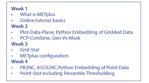
METplus Tutorial Series, weeks 1 to 4
Can't join us for the live sessions? No worries! All sessions will be made available on the METplus Training Page.
UFS Short-Range Weather Training
Summer 2021
The DTC, with Subject Matter Experts from NOAA's Environmental Modeling Center, National Severe Storms Laboratory, and Geophysical Fluid Dynamics Laboratory, had a training session for the Unified Forecast System (UFS) Short-Range Weather (SRW) Application, Sept 2021. Here is the Practical session focused on teaching community users how to set up and run the first officially released SRW Application for their own experiments. The SRW Application targets predictions of regional atmospheric behavior out to several days.
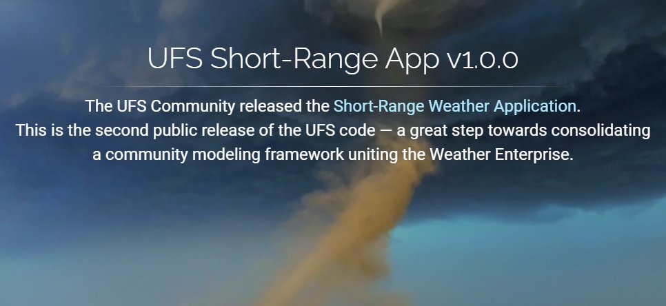
UFS Short-range Weather Application Version 1.0 has been released
Spring 2021
The latest Unified Forecasting System (UFS) application to be released is the Short-Range Weather (SRW) Application, which targets predictions of atmospheric behavior on a limited spatial domain and on time scales from less than an hour out to several days.
The SRW Application version 1.0 includes a prognostic atmospheric model, pre- and post-processing, and a community workflow for running the system end-to-end. Specific configurations of the release (e.g. model resolutions, domain location, and physics options) are documented and supported through an online forum.
The release is available through the GitHub repository.
Future work and releases will include:
- A more extensive set of supported developmental physics suites.
- A larger number of predefined domains/resolutions and a fully supported capability to create a user-defined domain.
- Inclusion of data assimilation capability.
- A verification package integrated into the workflow.
- Stochastic perturbations techniques.
Data on the Cloud
Winter 2021
NOAA’s Big Data Program (BDP) is providing public access to NOAA's open data on commercial cloud platforms through public-private partnerships with Amazon Web Services, Google Cloud Platform and Microsoft Azure. NOAA generates tens of terabytes of data a day from observations like satellites, radars, and buoys, and from weather models, and other sources. Did you know the available datasets include:
- UFS Coupled Model Prototype 5 (S2SP5), which is the latest experimental version of the UFS coupled atmosphere-ocean-sea ice model. This dataset is a significant intermediate stage in the ongoing development of the UFS seasonal to sub-seasonal application.
- Global Ensemble Forecast System (GEFS) v12 reforecasts for the upcoming GEFS v12 operational implementation. These retrospective forecasts span the period 2000-2019.
- Global Forecast Systems (GFS) Warm Start Initial Conditions for the operational deterministic medium-range numerical weather prediction, which are available four times per day for running forecasts at the 00Z, 06Z, 12Z and 18Z cycles, respectively.
- Other available datasets can be discovered through the registries on all these commercial platforms, including for example, Registry of Open Data on AWS.
Providing this data in the cloud significantly reduces the time needed to access and process the data, opening up new possibilities for in depth study and emerging areas of science. You are encouraged to use the available datasets. A broad collaboration among NOAA and non-NOAA scientists can accelerate innovation into operational modeling for weather and climate prediction.

Instructional Videos for MRW App v1.0 and CCPP
Autumn 2020
The Developmental Testbed Center has developed a set of instructional training videos. Two videos are now available to familiarize the NWP development community with the UFS code and the Medium-Range Weather (MRW) App v1.0.
- UFS Code Repositories describes the overall structure of the Medium-Range Weather Application ("MRW App") source code repositories, directory structures, and where to find further documentation.
- Raw Initial Conditions for the UFS Medium-Range Weather Application v1.0 describes the formats of raw initial conditions that can be used to initialize the MRW App v1.0 and how to stage them on disk to use with the App.
Three videos are available to familiarize the community with the Common Community Physics Package (CCPP).
- CCPP Suites introduces the components of Common Community Physics Package (CCPP) suites and explains how to add to, modify, or build a new suite.
- CCPP-Compliant Parameterizations describes how to make a physics parameterization CCPP-compliant.
- CCPP: Adding a Variable to a Scheme explains how to add a new variable to an existing CCPP-compliant scheme on the physics-scheme side, as well as on the host side (if using the UFS or CCPP Single Column Model).
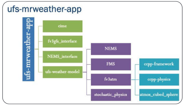
UFS MRWeather App
Community Workflow for the Limited Area Model Version of the FV3
Summer 2020
A workflow enabling users to run the atmospheric component of the Unified Forecast System
regional configuration (FV3-LAM) in an end-to-end capacity will soon be available to the broader
community. This community workflow is the result of a coordinated effort between EMC, GSL,
and DTC. Components of the workflow include experiment generation, Rocoto XML file
generation, and the scripts necessary to run pre-processing, model integration, and post-
processing. Collaboration across multiple labs fostered the development of a user-friendly,
modular system, allowing users to run their experiments in either a research/community mode
or in an NCEP Central Operations (NCO)-compliant environment, reproducing variable names
and directory structures used in operations at NCEP. Multiple computing platforms, external
model data sources, and CCPP physics suites are supported, with pre-defined domains already
provided for the user to choose from. The option to create a user-defined domain is also
available. The ultimate goal of the FV3-LAM community workflow is to support the general
research community, as well as facilitating research-to-operations by offering developers the
opportunity to test innovations within an NCO experiment environment to ease operational
transitions of model code at NCEP.
CONUS domain set up to run with the regional workflow
CCPP Framework
Is to be Used for Future Atmospheric Chemistry Modeling at NCAR
Spring 2020
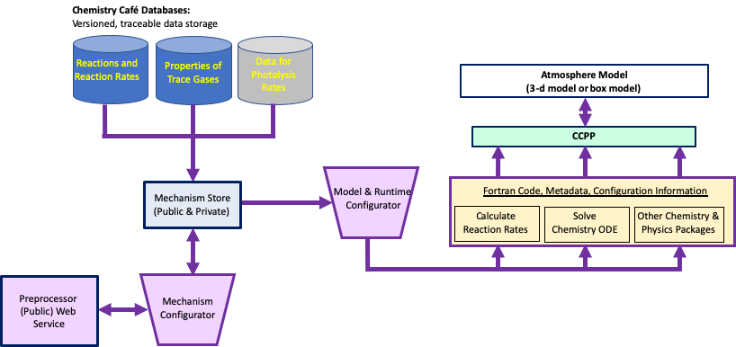
The Atmospheric Chemistry Observations and Modeling laboratory at NCAR has been developing the Model Independent Chemistry Module (MICM) to represent chemical transformations in any atmosphere model. To make this happen, MICM is designed to work with the Common Community Physics Package (CCPP) Framework, a software defining how host models access physics parameterizations including chemistry.
MICM gathers information on trace gases and chemical reactions from a database (coined the “Chemistry Café”). It then configures a set of reactions (chemical mechanism) and provides information on how the chemical transformations will be solved with a set of ordinary differential equations as well as how those gases are treated in the host atmosphere model. A data-flow diagram of this process is shown below. This suite of operations creates Fortran code, metadata, and namelist-type information for simulating the chemistry in the atmospheric model. The generated code is compliant with the CCPP Framework allowing MICM code to work with any atmosphere model that is also CCPP compliant.
MICM and its ability to function using the CCPP Framework has been tested with a simple chemistry scheme (5 reactions) in a chemical box model configuration. The box model successfully predicted the trace gas mixing ratios through several diurnal cycles. The MICM-generated Fortran code has also been successfully tested in the Whole Atmosphere Community Climate Model (WACCM) by “piggybacking” MICM trace gases with the WACCM full chemistry scheme (but not using CCPP yet).
Unique aspects of MICM include the use of a web service for the mechanism preprocessor, which allows easy maintenance and development. The Chemistry Café database, which includes trace gas properties along with chemical reactions, provides a single source of information that ensures consistent and traceable values between models and simulations.
Model Independent Chemistry Module (MICM)
MICM will become the core of the NCAR/ACOM chemistry parameterizations implemented in the Multiscale Infrastructure for Chemistry and Aerosols (MUSICA), a global chemistry transport model with regional refinement. MUSICA development is being implemented by the atmospheric chemistry community and is led by NCAR/ACOM scientists and software engineers.
METplus
Expanding Verification Capabilities Beyond the Basics
Autumn 2019
The Model Evaluation Tools (MET) were developed and released to the community by the Developmental Testbed Center more than a decade ago. At that time, the tools included computation of traditional statistics for continuous fields (temperature, pressure, and height) and dichotomous fields (precipitation, clouds, fog, and high impact events). MET also included a spatial verification method, using objects, which complemented traditional statistics.
Over the past five years, new flexibility and diagnostic options expanded MET capabilities. Support for calling a Python script from within MET was added to give researchers more control over the fields supported by MET and to allow for exploration of new methods. Additionally, a suite of Python wrappers now provides low-level automation for verification tasks. The resulting enhanced MET system is called METplus and is being adopted by DTC partners that want to tap into the power of an extensive toolset and unified verification capability.
Upcoming enhancements are driven by many projects within the DTC and through community contributions:
- More process-oriented diagnostics ranging from microphysical scales to sub-seasonal to seasonal scales.
- A renewed focus on enhancing MET-TC (Tropical Cyclone) to provide diagnostics in “cyclone-space.”
- Additional capability for: evaluating high-impact weather and atmospheric composition events, the use of satellite data, and evaluating components of a coupled prediction system.
Look for many of these enhancements in the METplus v3.0 release in late fall 2019.
There are Specialized Tools to Evaluate Innovations for NWP of TC's
Spring 2019
Model Evaluation Tools – Tropical Cyclone (MET-TC) was first developed in 2012 by the Developmental Testbed Center (DTC) as part of the Hurricane Forecast Improvement Project (HFIP) to provide a set of tools to aid in tropical cyclone forecast evaluation and verification. The primary goal of MET-TC was to replicate the functionality of the National Hurricane Center (NHC) verification software while utilizing the modular tools available within the MET software framework. The MET-TC software was first released with METv4.1, making the tools available to all users and enabling consistent forecast evaluation studies to be undertaken across the tropical cyclone modeling community. The initial tools provided a standard set of verification metrics and comprehensive output statistics with flexibility for user-defined stratification, which can be used for homogeneous comparisons of operational and experimental track and intensity forecasts. Graphical capabilities are also included with MET-TC, allowing easy visualization of verification statistics. Since the initial release, the tools have expanded through several DTC and non-DTC projects. Notable additions include:
- Rapid Intensification (RI) verification capabilities with user-defined thresholds (rirw)
- Ability to read Automated Tropical Cyclone Forecast (ATCF) Probability/Error Data Files (e-decks) and apply probabilistic methods to RI probabilities (-edeck, probrirw)
- Masking according to track and a circle of configurable radius around one or more lat/lon locations (gen_vx_mask)
- Application to shift gridded data field by source and destination lon/lat values (shift_data_plane)
- Feature-relative evaluation (METplus application)
New development is on the horizon to further enhance the tropical cyclone verification capabilities within the METplus system, these include:
- A new tool to convert model output to storm-relative coordinates and allow users to normalize by radius of maximum winds, compute azimuthal averages, derive tangential and radial wind (tc-rmw)
- A new tool to verify deterministic and probabilistic tropical cyclone genesis forecasts (tc-gen)
- Support for reading Statistical Hurricane Intensity Prediction Scheme (SHIPS) diagnostics files
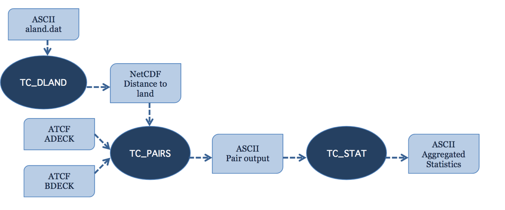
Basic representation of the structure of the MET-TC module. Dark blue areas represent each executable and light blue areas represent required input and output to MET-TC.
The Next Generation Global Prediction System
Summer 2018
The Next Generation Global Prediction System (NGGPS) multi-year Strategic Implementation Plan (SIP) connects federal and academic experts in the numerical weather prediction community to support the end-to-end functionality of the National Centers for Environmental Prediction (NCEP) Production Suite. The goal of the SIP is to help evolve the NGGPS into a Unified Forecast System (UFS) for operations and research.
-
The SIP governance includes UFS Working Groups who represent the essential science, technical, and design capacity of the UFS and span the community of expertise needed to support it.
-
UFS Working Groups consist of subject matter experts across NOAA line offices and laboratories, Navy, NASA, NCAR, and Universities.
-
The SIP Working Groups are always seeking members from the research and development community.
For more information on the SIP process, please visit: https://www.weather.gov/sti/stimodeling_nggps_implementation
About Software containers
Spring 2018
Porting is the ability to move software from one environment to another by making minimal changes to the existing code. Unfortunately, such an arrangement is not easy to achieve when it comes to porting software from one Operating System (OS) platform to another or even among versions of a single OS. Software containers are a solution to this problem. The software and its working environment are able to be ported from platform to platform, from a laptop to a desktop or HPC environment as a unit, single and complete. The container bundles the software package, configuration files, software libraries and other binaries needed to run the software. Simply put, when you containerize a package and its dependencies, a portable platform is created. The differences in infrastructure and variations in OS releases are basically eliminated.
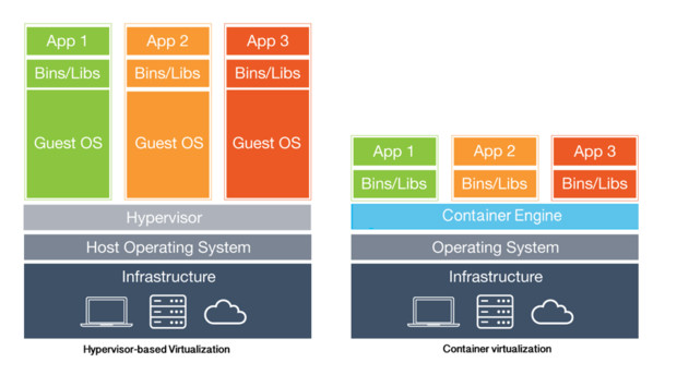
A VM is called a virtual machine, because that's what it is. It's a server that exists only in the virtual world, enabled by the hypervisor software. A container is called a container because it steals from the idea of shipping containers. Credit for image and caption, https://www.linkedin.com/pulse/3-drastic-reasons-containers-causing-seismic-shift-mark-shavers
A single column model (SCM) can be an easy, quick, and cheap way to test new or updated physics schemes
Autumn 2017
A SCM replaces advection from a dynamical core with forcing that approximates how the atmospheric column state changes due to large-scale horizontal winds. An atmospheric physics suite then calculates impacts to radiation, convection, microphysics, vertical diffusion and other physical processes as the forcing alters the column state.
The SCM approach is conceptually simple, extremely quick to run (less than a minute on a laptop), and makes interpretation of results less ambiguous because it eliminates three-dimensional dynamical core feedbacks. It can also be relatively straightforward to compare how different physics respond to identical forcing and to perhaps provide evidence or justification for more expensive three-dimensional modeling tests.
The DTC’s Global Model Test Bed (GMTB) project built an SCM on top of the operational Global Forecast System (GFS) physics suite and used it as part of a physics test harness. It can be considered the simplest tier within a hierarchy of physics testing methods. Recently, it has been used to compare how the operational GFS suite performs compared to one with an advanced convective parameterization for simulations of maritime and continental deep convection.
The SCM code is available to collaborators on NOAA's VLab, and will be updated periodically to keep pace with changes in the operational FV3-GFS model. Additionally, as the Common Community Physics Package comes online in the near future, the SCM will be compatible with all physics within that framework.
Join Weekly Webinar Discussion on EMC’s Forecast Systems
Winter 2017
You can join weekly webinars to discuss the performance of EMC’s forecast/analysis systems from a synoptic and mesoscale perspective.
- The weekly webinar is led by EMC’s Model Evaluation Group and participants include model developers, NCEP service centers, NWS regional and field offices, DTC staff, academic community and private sector.
- Webinars serve as a forum for EMC to reach out to forecast and user community
Interested in participating? Contact Glenn White or Geoff Manikin
Here's a conference abstract of Glenn's on this group too
https://ams.confex.com/ams/97Annual/webprogram/Paper313180.html
Documentation is important!
Summer 2017
A Google Search:
Documentation is the Most Valuable Thing You Do (from cyborginstitute.org/projects/administration/documentation/).
Good documentation makes software and tools more valuable and more durable, and although documentation can be a great expense, in the long term it’s almost always worthwhile.
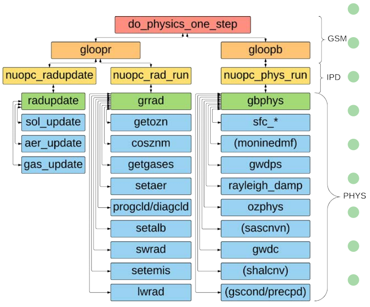
The schematic diagram representing the GFS Physics calling structure.
As part of its effort to set up a framework for a Common Community Physics Package (CCPP), the DTC’s Global Model Test Bed is documenting the Global Forecast System’s operational physics suite using “Doxygen” software.
Doxygen is [a] tool for generating documentation from popular programming languages include Python, Fortran, C, C++, IDL
This software parses specially formatted in-line comments and creates navigable and searchable web documents.
For the GFS physics suite, documentation is written within Fortran code, so is relatively easy to keep up-to-date as new developments are added to the model.
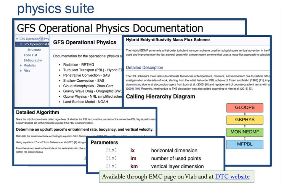
GFS Operational Physics Documentation
Did you know there are suggested topics for Visitor Projects that receive special consideration?
Autumn 2016
-
Advance the forecast skill of the DTC-supported HWRF modeling system through improved physics and/or initialization
-
Advance the analysis capability of the DTC-supported Gridpoint Statistical Interpolation and/or the NOAA Ensemble Kalman Filter (EnKF) Data Assimilation systems through development, testing, and evaluation of advanced data assimilation techniques and the addition of new data types or measurements
-
Transition innovations in atmospheric physical parameterizations to NOAA’s Next-Generation Global Prediction System (NGGPS)
-
Adding new capabilities to the Model Evaluation Tools
For more information and to apply, go to http://www.dtcenter.org/visitors/
Establishing a Functionally Similar Operational Environment for the Hourly-Updating NAM Forecast System
Summer 2015
As a bridge between the research and operational NWP communities, one of the fundamental purposes of the DTC is to provide the research community access to functionally similar operational environments. Through this effort, promising new NWP techniques from the research community can be transferred more efficiently to an operational environment. One system that is currently under development and in the plans for operational implementation is the North American Mesoscale Rapid Refresh (NAMRR) system. The NAMRR is an hourly-updating version of the North American Mescoscale (NAM) forecast system, which is based on NOAA’s Environmental Modeling System (NEMS) Nonhydrostatic Multiscale Model on the B-grid (NMMB). In addition to the deterministic forecast guidance provided by NAMRR, it will also be a major contributor to the future Standard Resolution Ensemble Forecast (SREF) and High Resolution Ensemble Forecast (HREF) systems, along with the Rapid Refresh (RAP) and High Resolution Rapid Refresh (HRRR) systems, which are based on the Weather Research and Forecasting (WRF) model. The NAMRR system is being actively ported to the DTC. The configuration currently includes a 12-km North American parent domain and a 3-km CONUS nest, with plans to add a 3-km Alaska nest (Figure center of page). Future plans include providing support to the research community to run a functionally similar NAMRR environment.
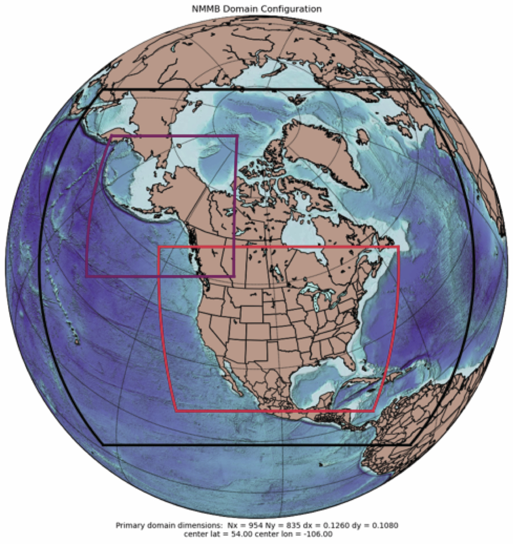
Establishing a Functionally Similar Operational Environment for the Hourly-Updating NAM Forecast System
Research and Operational Communities Gathered for Physics Workshop Recently
Winter 2015
A successful workshop on Parameterization of Moist Processes for Next-Generation Weather Prediction Models was hosted by NOAA and DTC at the NOAA Center for Weather & Climate Prediction (NCWPC) in College Park, MD, Jan 27-29, 2015. A large number of participants from NOAA, the international operational community, and the research community gathered to discuss topics including microphysics, sub-grid scale clouds and turbulence, and deep convection. The first day of the workshop included two keynote presentations and several foundational presentations on the state-of-the-science and current operational status at NCEP for the three topic areas. The second day consisted of breakout discussions allowing for in-depth conversation and idea sharing. A plenary wrap-up session was held on the morning of the third day. A list of the participants, along with the agenda and links to the presentations are available on the workshop website at:
Workshop attendees for the workshop on Parameterization of Moist Processes for Next-Generation Weather Prediction Models
NOAA TESTBEDS & THE DTC
Winter 2014
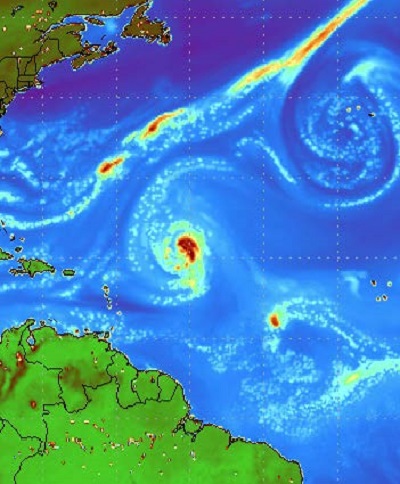
During California field exercises of the Hydrometeorological Testbed (HMT), a key objective has been to improve longer-range forecasts of so-called “atmospheric rivers” or ARs (narrow streams of mid- to low-level moisture) and other meteorological patterns that produce very heavy rainfall. During efforts to evaluate model forecasts for these exercises the DTC has explored methods that can provide more meaningful verification than standard scores. One such method represents regions of, say, precipitation in model forecasts and observed fields as spatial objects and then quantitatively compares attributes of these objects such as size, location, geographical overlap, etc. Since the landfall of moisture on the Western U.S. coastline is a key factor in AR forecasts, a novel approach for this project has been to define objects within thin domains that follow the coastline (as in the figure), and to choose actual moisture transport as a basis for the fields from which to define objects. The narrow coastline-hugging domain allows the MODE (the Method for Object-Based Diagnostic Evaluation) evaluation to focus on actual landfall of moisture, a key factor in the effort to forecast severe precipitation in California and other regions vulnerable to ARs.
NOAA TESTBEDS & THE DTC
Spring 2013
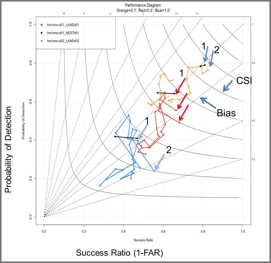
For several winter seasons, the DTC has worked with the Hydrometeorology Testbed (HMT) to develop effective verification techniques for ensemble forecasts of heavy winter precipitation associated with atmospheric rivers in California. For example, the performance diagram below displays the impact of model resolution. See additional HMT information and links on the DTC website. See http://www.dtcenter. org/eval/hmt/2012/.
Did you know....
Summer 2013
Through its Visitor Program, the DTC is currently working with Adam Clark, a scientist at the Cooperative Institute for Mesoscale Meteorological Studies (CIMMS), on a project that involves using the Method for Object-based Diagnostic Evaluation – Time Domain (MODE-TD) for identification, tracking, and visualization of simulated supercells in high-resolution models, which will be applied and tested during annual NOAA/Hazardous Weather Testbed Spring Forecasting Experiments.
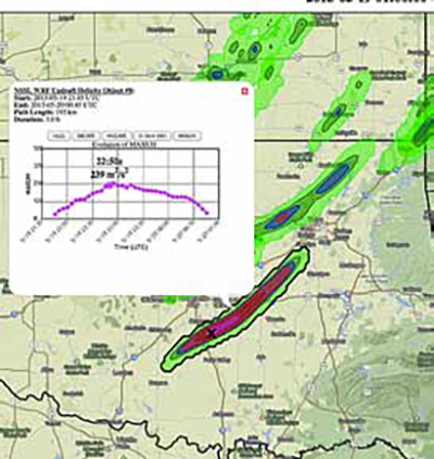
Supercells are identified using updraft helicity (UH) extracted at 5-minute intervals from an experimental 4-km grid-spacing version of the WRF model run in real-time at the National Severe Storms Laboratory (NSSL), which is known as the NSSL-WRF. The UH extraction is done using a newly developed technique that minimizes data volume, and supercells are defined based on maximum intensity and longevity criteria applied to UH objects identified by MODE-TD. Geographic information and object attribute information are then combined into the GeoJSON file format and displayed using an experimental web interface developed in collaboration with Chris Karstens of CIMMS/NSSL, known as the NSSL Experimental Data Explorer. The image above is a screenshot from the data explorer showing the path as depicted by UH and associated attributes of a simulated supercell over central Oklahoma 19 May 2013.
TESTBEDS AND THE DTC
Autumn 2013
The Tropical Cyclone Modeling Team (TCMT) was formed as part RAL’s Joint Numerical Testbed (JNT) in 2009 to help assess hurricane and tropical storm forecasts from experimental models. As such, its members interact with the DTC in two particular ways: by designing methods and products appropriate for tropical cyclone verification that can be installed in maintained software at the DTC, and by providing both real-time and retrospective performance measures for each years’ hurricane forecasts. At a working level, members of the TCMT are often contributing DTC members as well.
The intent of the yearly retrospective evaluations are to provide guidance to the National Hurricane Center as they choose particular experimental forecast models to use for operational guidance during the upcoming hurricane season. In recent years these retrospective studies have focused on hurricane track and intensity forecasts from suites of comparison models forwarded by universities, research laboratories, and national centers. This evaluation is intended to help achieve the goals of NOAA’s Hurricane Forecast Improvement Project (HFIP), a program in which the DTC hurricane task is also involved.
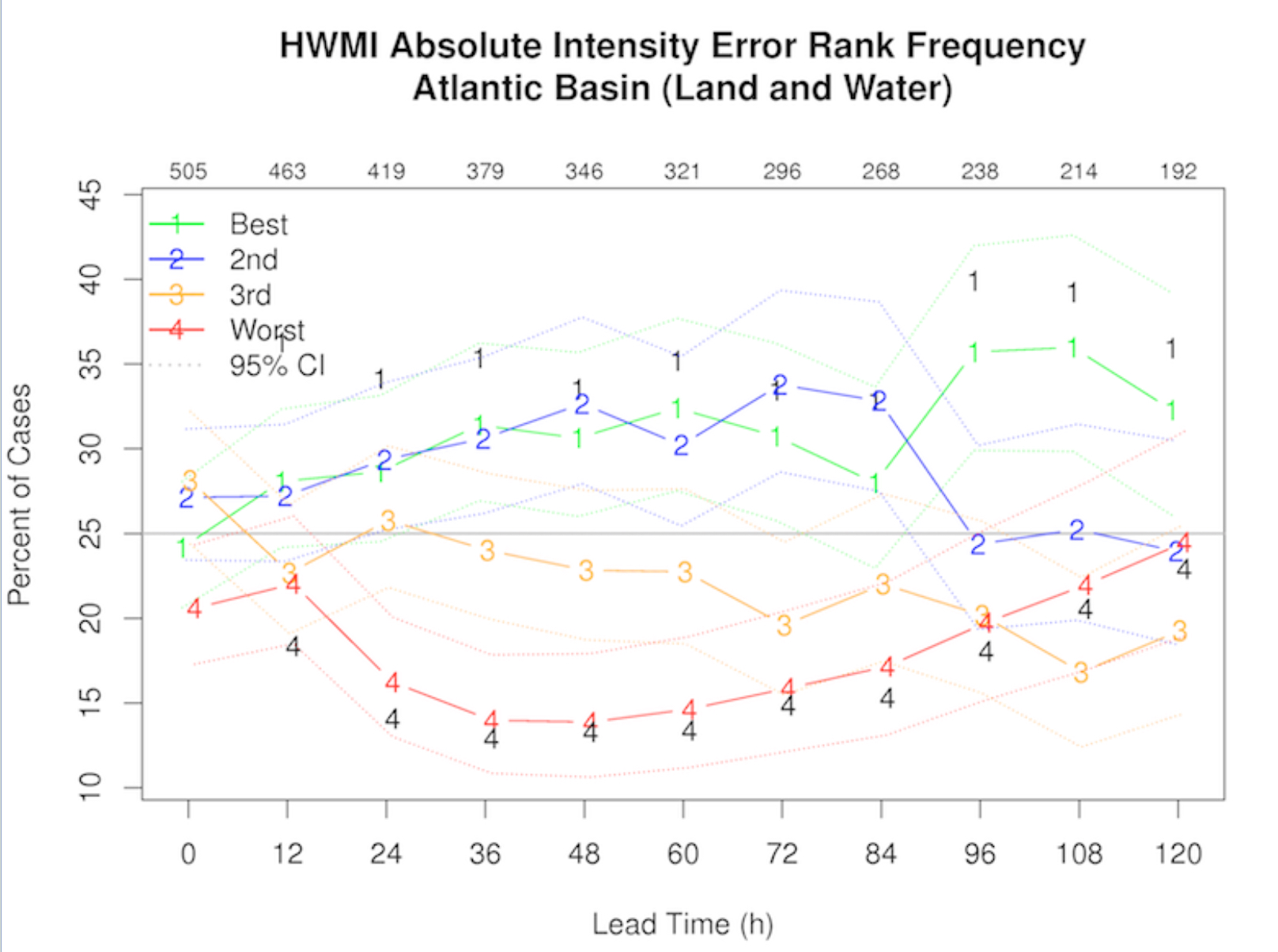
The accompanying figure, to the right, illustrates some results from the 2013 Retrospective Exercise (covering hurricane seasons 2010-2012). In the figure, the rank of a single experimental model hurricane intensity forecast is shown relative to that of the three top performing models. As a general rule, while hurricane tracking has dramatically improved in recent years, better intensity forecasts remain elusive.
The Formal FV3GFS Evaluation
Winter
Implementing the GFS global model with the FV3 dynamic core upgrade into the National Centers for Environmental Prediction (NCEP) Production Suite will be the first step towards a Unified Forecast System (UFS). But prior to any new code being delivered to NCEP Central Operations, the NCEP Director must decide whether the implementation should occur, based on recommendations from the Environmental Modeling Center (EMC) and customers and stakeholders in the field at the conclusion of a formal evaluation period. EMC’s Model Evaluation Group (MEG) is part of the Verification, Post Processing, and Product Generation Branch in EMC and provides independent validation of new or revised models. To assist the field in making their recommendations on a new model or major upgrade, the MEG is tasked with providing information on the model and its performance through webinars and online material, and then making its own formal recommendation.
As the cornerstone of the five-month evaluation period, the MEG created a single, central location web site where users could view data, obtain files, get detailed information about the model, and see statistics from both the real-time parallel testing and three years of retrospective runs. The MEG devoted eleven of its weekly webinars to discussions on expectations for the evaluation. This included issues with new products, resolution of problems seen in the parallel output, statistical and subjective assessment of model performance on standard performance metrics, and high-impact cases involving hurricanes, winter storms, major rainfall, severe weather, and extreme hot and cold temperatures. The collaboration with partners across the weather enterprise to evaluate the GFS with the FV3 core was unprecedented in terms of comprehensiveness and scope. Implementation of the GFS with the FV3 upgrade is currently scheduled for January 2019.
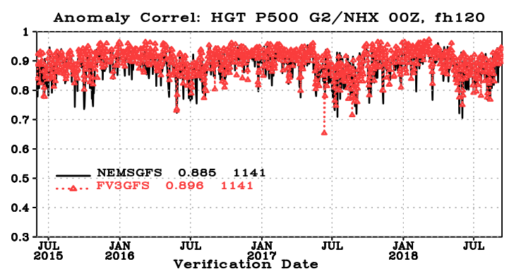
Figure 1. The 500 hPa day 5 anomaly correlation scores for forecasts covering a 3-year retrospective period from the FV3 version of the GFS (red) compared to the operational GFS (black).
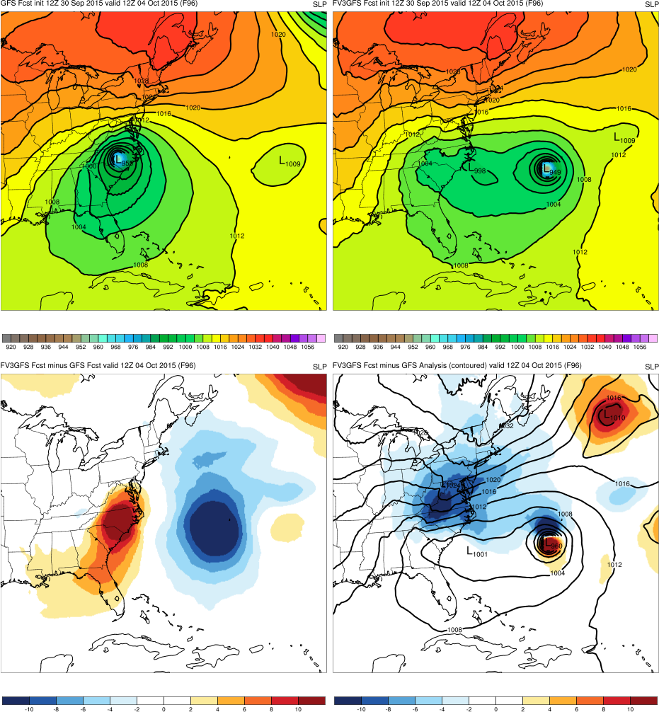
Figure 2. Graphics taken from the retrospective assessments page of the MEG website for the GFS upgrade. This image compares 96-hour Hurricane Joaquin forecasts from the GFS with the FV3 core (upper left) and the then operational GFS (upper right) for the 1200 UTC cycle on 4 October 2015, with a difference field in the lower left and the verifying GFS analysis (lower right, contours) along with difference between the analysis and the GFS forecast with the FV3 upgrade (contoured).
Contact
303.497.8921
dtcenter@ucar.edu
Addresses
mailing:
PO Box 3000
Boulder, CO 80307-3000
Shipping:
3090 Center Green Dr.
Boulder, CO 80301
Follow Us
Copyright © 2024. All rights reserved.