Transitions Newsletter Header

Issue 1 | Spring 2013

Lead Story

Mesoscale Model Evaluation Testbed

ASSISTING WITH THE TRANSITION OF PROMISING NWP TECHNIQUES FROM RESEARCH TO OPERATIONS
Contributed by J. Wolff, C. Phillips

The DTC provides a common framework for researchers to demonstrate the merits of new developments through the Mesoscale Model Evaluation Testbed (MMET).

Established in the Fall of 2012, MMET provides initialization and observation data sets for several case studies and week-long extended periods that can be used by the entire numerical weather prediction (NWP) community for testing and evaluation. The MMET data sets also include baseline results generated by the DTC for select operational configurations.

To date, MMET includes nine cases that are of interest for the National Centers for Environmental Prediction/ Environmental Modeling Center (NCEP/EMC). A brief description of each case, along with access to the full data sets is available at http:// www.dtcenter.org/eval/mmet. Researchers are encouraged to run several case studies spanning multiple weather regimes to illustrate the versatility of this new innovation for operational use.

“Researchers are encouraged to run several case studies to illustrate the versatility of the system.”

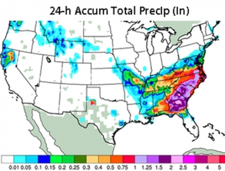
One particular case available in MMET is 28 February 2009, when nearly 7 inches of snow fell in Memphis, TN. A squall line marched through the Southeast along the leading edge of a cold front, prompting three tornado and several high-wind reports. The next two days (1-2 March), snow fell from Atlanta to New York, dropping up to a foot of snow in some areas. The figure above shows the two day precipitation accumulation. This case is of interest to NCEP/ EMC because the North American Mesoscale (NAM) model quantitative precipitation forecast valid 1 March shifted precipitation too far north, missing a rain/snow mix in Georgia and falsely predicting snow in western parts of the Carolinas.

If improved forecast accuracy is demonstrated through objective verification results with MMET cases, the technique can be submitted for further extensive testing by the DTC.

Community users can nominate innovations for more extensive DTC testing by filling out the nomination form (http://www.dtcenter.org/eval/ mmet/candidates/form_submission. php).

As MMET continues to mature, additional cases will be made available to broaden the variety of available events in the collection. Submissions for additional cases to be included in MMET are accepted at: http://www. dtcenter.org/eval/mmet/cases/form_ submission.php. For more information on the testing protocol process defined to accelerate the transition of mesoscale modeling techniques from research to operations, please see http://www.dtcenter.org/eval/mmet/ testing_protocol.pdf.

Comments and questions regarding MMET or any stage of the testing protocol process can be directed to Jamie Wolff (jwoff@ucar.edu).


Director's Corner

Welcome Message by Bill Kuo

Dear Colleagues,
Contributed by Bill Kuo, DTC Director

Welcome to the first issue of a quarterly newsletter for the Developmental Testbed Center (DTC). The research to operations (R2O) transition in numerical weather prediction (NWP) is a major challenge facing the U.S. meteorological community. It has been recognized that the U.S. has the largest community around the world working on weather research and numerical modeling. Yet, most of these research results do not directly benefit operational NWP. The DTC was established in 2003 with a mission to facilitate the transition of research innovations in regional modeling into operations.

An effective R2O process requires active participation of research and operational communities. With this quarterly newsletter, we hope to provide a forum for discussion of important issues facing the NWP community. We will also provide updates on DTC activities that are of interest to the community.

We welcome articles submitted for consideration for publication in upcoming issues.


Who's Who

John Halley Gotway

If you’ve submitted a question to the MET help desk, or attended a MET tutorial, there’s a very good chance that you already know John Halley Gotway. John joined NCAR’s Research Applications Laboratory (RAL) as a software developer in 2004 and has been contributing to the verification efforts within RAL and the DTC. John’s background is in mathematics.

He worked in Los Angeles at Northrop Grumman, before NCAR and the Rockies drew him to Colorado. His expertise is in numerical verification techniques. In particular, his fingerprint is on much of the internal workings of the MET code. He has also played several roles in applying MET to many testing and evaluation projects.

Outside of work, John’s children, Otis (7), Robin (4), and Cate (1) keep him very busy. One thing you may not know is that besides computing expertise, John contributes directly to critical RAL protein intake by providing fresh eggs from his “gentlemen’s farm” near Longmont. Next time you call or email him with a C++ question, ask him how his chickens are doing.


Bridges to Operations

Innovation in HWRF 2013 Baseline

Contributed by Ligia Bernardet

One of the regional numerical weather prediction models used operationally by the National Weather Service is the Hurricane WRF (HWRF), a coupled model with atmospheric and ocean components that exchange fluxes of short- and long-wave radiation, momentum, moisture, and heat. The momentum flux is particularly important because the strong winds in tropical cyclones cause turbulence and upwelling in the ocean, which can lead to transport of cold water from deep in the ocean towards the surface, reducing the storm’s energy source and causing it to weaken.

Comparison

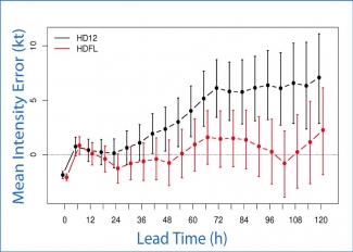
A comparison between the ocean cooling in HWRF against observational buoy data, performed by the Hurricane Research Division of NOAA’s Atlantic Oceanographic and Meteorological Laboratory, showed that the ocean surface cooling in HWRF is too small. The DTC worked with the NOAA Environmental Modeling Center and oceanographers from the University of Rhode Island to formulate a test in which the momentum flux in the ocean model was altered to be more physically consistent. The figure below shows the mean intensity error as a function of lead time for 2012. The black curve is the control and the red curve is the forecast with modified fluxes with 95% confidence intervals.

Results

Results aggregated over all 2012 Atlantic storms showed the more physical flux reduced the 5-kt positive intensity bias of the operational model to near-zero. This change has been incorporated by EMC into the 2013 HWRF baseline, and is expected to be adopted operationally for the 2013 hurricane season.


Did you know?

NOAA TESTBEDS & THE DTC

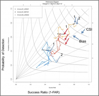
For several winter seasons, the DTC has worked with the Hydrometeorology Testbed (HMT) to develop effective verification techniques for ensemble forecasts of heavy winter precipitation associated with atmospheric rivers in California. For example, the performance diagram below displays the impact of model resolution. See additional HMT information and links on the DTC website. See http://www.dtcenter. org/eval/hmt/2012/.