Transitions Newsletter Header

Issue 14 | Summer 2017

Lead Story

Community Modeling Workshop Outcome

Contributed by Mike Farrar
“The most common feedback from the workshop participants noted the increase in transparency within the EMC and NOAA at large, the increasing effort to engage the entire community, and the general sense of positive momentum of the community coming together to embrace the opportunity to use NGGPS as a foundation to build a true community modeling resource for the Nation.”

DTC Article on NOAA Community Modeling Workshop and SIP Working Group meetings

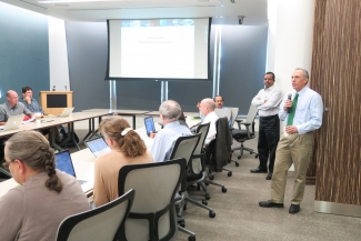
The NOAA Community Modeling Workshop and meetings of the Strategic Implementation Plan (SIP) Working Groups were held 18-20 April  2017 at the National Center for Weather and Climate Prediction in College Park, Maryland.  The goal of the meetings was to seek engagement with the Earth system science community to form and shape the nascent unified modeling community being built upon the Next Generation Global Prediction System (NGGPS), and to consider how to best execute shared infrastructure, support, management, and governance.  Other topics addressed include identifying “best practices,” discussing how a community-based unified modeling system will actually work, and to evolve and coordinate between SIP/NGGPS Working Groups (WGs). A complete set of documents for the meeting, including the agenda, participant list, presentations, and summary reports are found on the workshop webpage: https://ral.ucar.edu/events/2017/community-modeling-workshop. For more information on the SIP effort, see the “Director’s Corner” article in the Winter 2017 issue of DTC Transitions.

The NOAA Community Modeling Workshop, which ran from 18 April through noon on 19 April, was designed to interact with the broader model R&D community.  As such, this portion was completely open to the public, and included a dial-in capability for the plenary sessions.  The opening talks set the stage by describing the approach and goals of the Next Generation Global Prediction System (NGGPS), and a summary of the SIP and its goals and objectives.  These opening talks were followed by a panel discussion of senior leaders from the weather enterprise, including the Directors of NWS and NOAA Research, UCAR President, and senior leaders from academia, private sector, NASA, National Science Foundation, and DoD (Navy).  Each were asked to provide their perspective on three items:

  1. What aspects of a NOAA-led community to develop next-generation unified modeling system would your organization and sector find advantageous?  In other words, how do you think your organization/sector would benefit?
  2. For which parts of a community unified modeling effort would your organization or sector be best able (and most likely) to contribute? In other words, what do you feel is the best role for your organization/sector to play?
  3. From the perspective of your organization or sector, what do you see as the greatest challenges to be overcome (or barriers that must be broken down) to make this a successful community enterprise?

The remainder of the presentations were panel discussions featuring co-chairs from 12 active SIP WGs, each of whom provided their perspective on the ongoing activities of their WG and the overall effort to migrate the NGGPS global model, under development within NOAA, into a community-based unified modeling system.

The workshop concluded on the morning of 19 April with a series of parallel break-out groups, each of which was asked to provide their assessment based on what they saw and heard during the presentations to identify two categories of items:

  1. Best practices: What are the major things that we’re getting right?
  2. Gaps: What are the major things that we’re missing, or heading down the wrong track?

Note: Reports from these breakout sessions can be found in the workshop summary.

The SIP Working Group meeting, which ran from the afternoon of 19 April through the end of 20 April, consisted of a series of meetings between the various SIP Working Groups (WG) aimed at advancing the technical planning within each WG and ensuring that this technical planning is well-coordinated across WGs.  These meetings, also referred to as Cross-WG meetings, were also designed to identify areas of overlap vs. gaps between the WGs, and to help facilitate technical exchange.

Each WG was asked to provide (1) an overall assessment of the effectiveness of the workshop, (2) a summary of “immediate needs” they felt needed to be worked ASAP to ensure success in the long term, and (3) items on the “critical path” that were most important upon which others depended.  A summary of the “immediate needs” and “critical path” items are provided in the SIP meeting summary, which includes the full reports from each WG.

The overall consensus of the meeting participants for both portions of the workshop was very positive, with the most common feedback noting the increase in transparency within the Environmental Modeling Center and NOAA at large, the increasing effort to engage the entire community, and the general sense of positive momentum of the community coming together to embrace the opportunity to use NGGPS as a foundation to build a true community modeling resource for the Nation.


Director's Corner

Bill Kuo

Contributed by Bill Kuo

The Developmental Testbed Center (DTC) was established in 2003 with a mission to facilitate research to operation transitions in regional Numerical Weather Prediction (NWP). The DTC fulfills this mission by (i) providing community support for regional operational systems, (ii) performing testing and evaluation of NWP innovations for possible operational implementation, and (iii) promoting interaction and collaboration between research and operational NWP communities through special workshops, visitor programs, and the publication of this newsletter.

The Developmental Testbed Center (DTC) was established in 2003 with a mission to facilitate research to operation transitions in regional Numerical Weather Prediction (NWP).

When the DTC was first established, the initial focus was the Weather Research and Forecasting (WRF) model. In fact, during the early days the DTC was called the “WRF” DTC. Over the years, the scope and activities of the DTC have expanded in response to the needs of operational centers and the research community. Today, the DTC provides support for five community systems, including WRF, UPP (Unified Post-Processor), HWRF (Hurricane WRF), GFDL vortex tracker (a component of HWRF), GSI-EnKF data assimilation system, and the MET (Model Evaluation Tools) verification system. This work has been valuable in encouraging the research community to use operational NWP systems for research applications, and has contributed to their continued improvement.

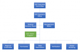
Currently, efforts are grouped into five task areas focused on the operational systems the DTC supports: Regional Ensembles, Hurricanes, Data Assimilation, Verification and Global Modeling. The Global Modeling task was added in 2015, in response to the request from the NWS NGGPS (Next Generation Global Prediction System) Program Office, to establish a Global Model Test Bed (GMTB). The development and community support of a Common Community Physics Package are the initial foci of GMTB.

A key objective of the NGGPS program is upgrading the current operational Global Forecast System (GFS) to run as a unified, fully-coupled model within the NEMS (NOAA Environmental Modeling System) infrastructure. This unified model is expected to improve hurricane track and intensity forecast, and extend weather forecasting out to 30 days, in addition to other objectives. The NGGPS program presents an exciting opportunity for the U.S. NWP community to collaborate on the development of a single modeling system, which can then be used to support both the research and operational sectors.

In the last issue of the DTC Transitions Newsletter, Environmental Modeling Center (EMC) Director Mike Farrar articulated how the migration of the legacy GFS spectral model dynamic core to the FV3 (Finite Volume Cubed Sphere Version 3) core represents a first step toward unified modeling. The consolidation of EMC’s modeling suite will concentrate resources and result in considerable savings.

The DTC Executive Committee has asked the DTC to develop a strategic vision for the next 10 years to ensure it evolves hand-in-hand with the operational center, and aligns its activities in support of the unified modeling transition. This is a very welcome request -- it has been challenging to support multiple modeling systems with limited resources.

This summer, DTC staff will begin to develop this new vision. The overarching question is: “What is the role of the DTC in the NGGPS era with unified modeling?” How should a complicated unified and fully-coupled Earth system model with multiple components be supported to the community, and what is the DTC’s role in the support of such a system? With limited resources, where should the DTC focus its testing and evaluation efforts to most effectively facilitate R2O transition? How effective are the DTC community engagement activities and should they be revised to further support collaboration and interaction between research and operational NWP communities?

Our goal is to develop a draft strategic vision by the end of the summer. The DTC Strategic Vision will be vetted with the DTC Science Advisory Board and the DTC Management Board, before it is submitted to the DTC Executive Committee for consideration.



Who's Who

Jamie Wolff

I grew up in Mound, MN, which is a western suburb of the Twin Cities. While most would consider Minnesota a cold and snowy state, I apparently wanted colder and snowier weather because I decided to head further north to Grand Forks, ND to attend the University of North Dakota (UND). I am an avid UND hockey fan and love heading to the games when they come out to play University of Denver or Colorado College in Colorado. Experiencing bitterly cold temperatures walking to class at UND certainly made me appreciate the amazing weather we have here in Colorado! I do have one lasting piece of home - I love shoveling snow and will choose to do so knowing that most of the time around here it will melt in a day or two!

I graduated from UND in the spring of 2000 and started working in the Research Applications Laboratory (RAL) at NCAR a few weeks later; I feel very fortunate to still be here 17 years later! I have been involved with a lot of projects in RAL over that time, including aviation weather, road weather, and numerical weather prediction (NWP). For each of those tasks I have generally been involved with statistics and performance assessment of algorithms or models. Currently, I conduct NWP testing and evaluation within the Regional Ensemble and Global Model Test Bed groups in the DTC. I have learned a lot over the years working with some very distinguished researchers at NCAR and NOAA.

I went to UND in pursuit of an atmospheric sciences degree and in addition came away with a future husband, Cory, who also works at NCAR as a project manager for the National Science Foundation aircraft. We have one daughter who keeps us busy attending volleyball and choir/orchestra events. We love to travel around our beautiful state and beyond. The travel experience I treasure the most to-date is spending time in Sydney, Australia and seeing the Sydney Symphony Orchestra play at the iconic Opera House. This is what inspired my 4th grader at the time to start playing a string instrument! In my free time I love to knit, having just finished my first sweater, and generally like to be outside hiking, jogging, skiing, dabbling in photography, or looking for agates to polish.

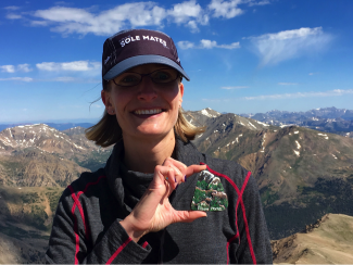
Jamie Wolff conquered Colorado’s highest peak, Mount Elbert at 14,400 feet.


Bridges to Operations

The Unified Post Processor

Contributed by Kate Fossell

Post-processing is an essential but often overlooked component of numerical weather prediction and encompasses a broad range of concepts, methods, and tools to make raw model output more useful. The Unified Post Processor (UPP) can compute a variety of diagnostic fields, interpolate to pressure levels or specified (pre-defined or custom) grids, and de-stagger grids. Examples of the products include:

  • T, Z, humidity, wind, cloud water, cloud ice, rain, and snow on isobaric levels
  • SLP, shelter level T, humidity, and wind fields
  • Precipitation-related fields
  • PBL-related fields
  • Severe weather products (i.e. CAPE, Vorticity, Wind shear)
  • Radiative/Surface fluxes
  • Cloud related fields
  • Aviation products
  • Radar reflectivity products
  • Satellite look-alike products

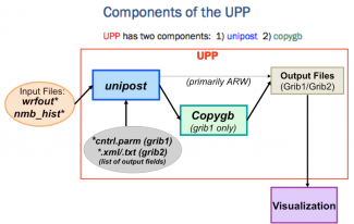
The UPP produces GRIB1 and GRIB2 output files that can be used directly by a number of plotting packages and the Model Evaluation Tools (MET) verification package.

UPP Components version 3.1.

The UPP is used to post-process operational models such as the Global Forecast System (GFS), GFS Ensemble Forecast System (GEFS), North American Mesoscale (NAM), Rapid Refresh (RAP), High Resolution Rapid Refresh (HRRR), Short Range Ensemble Forecast (SREF), and Hurricane WRF (HWRF) applications.  The DTC serves as a bridge between operations and the community, and provides UPP software and support for the Weather Research and Forecasting (WRF) modeling core.  Since the UPP is used in operations; users can mimic the production of operational products through the community UPP distribution. Another advantage is its efficient handling of large datasets because it’s a parallelized code. 

One of the more popular features among community users is the ability leverage the Community Radiative Transfer Model (CRTM) to output synthetic satellite products.  Other favored features include vertical interpolations of certain products, such as radar reflectivity ¼ km above ground level (AGL), and the horizontal grid manipulation capability. In addition, users have recently leveraged UPP as a tool to post-process WRF simulations into GRIB output. Required fields can then be used as input to initialize another WRF simulation.

The DTC’s UPP team works directly with community developers to incorporate their contributions into the code base, and serves as a liaison to integrate new features into the operational code.  The UPP team also continues to expand and improve documentation to help the community use and contribute to the UPP software package.  Look for a new online tutorial coming later this year!

UPP v3.1 is the most recent version available, and was released in the Fall 2016.  The next release can be expected in Summer or Fall of 2017.  More information can be found on the UPP website: http://www.dtcenter.org/upp/users/.


Visitors

Evaluating Convective Structure

Visitor: Mariusz Starzec
Contributed by Mariusz Starzec

As a visitor to DTC in 2016, University of North Dakota Ph.D. candidate Mariusz Starzec investigated the performance of regional summertime convective forecasts. In particular, he focused on model skill in predicting the coverage, morphology, and intensity of convection. Further emphasis was placed on how representative the simulated internal convective structure is of observed convection by using the reflectivity field as proxy for convective processes.

Convection plays a major role in everyday weather and long term climate. Any biases present in convective forecasts have important implications on the accuracy of operational forecasts, potential severe weather hazards, and climatic feedbacks. Validation of model forecasts are required to identify if any of these biases exist.

For the DTC project, four months of forecasts from six 3-km Weather Research and Forecasting (WRF) model configurations were assessed, where one of the configuration was the High Resolution Rapid Refresh (HRRR). The WRF configurations consisted of a combination of varying microphysics and model versions. The simulated reflectivity field was compared against the radar-observed reflectivity field, which is an instantaneous snapshot into what is occurring in the convective system. More importantly, this approach allows for the entire three-dimensional vertical structure of convective systems to be evaluated.

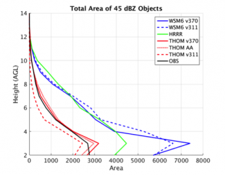
Total area of discrete objects above 45 dBZ with height for a variety of models simulations (colored) and observations (black).

Forecasts were analyzed using an object-based approach, where bulk attributes of discrete storm cells are emphasized instead of exact timing and location. Object counts and their respective areas with height were evaluated, along with the vertical distribution of reflectivity values within these objects. Overall, convective forecasts were generally more intense, contained more and larger objects, and covered more area than observed convection. The largest over-predictions occurred during the peak in the diurnal cycle. No major differences were found between model versions, although varying the microphysics caused large differences in the vertical distributions of object counts and areas.

Vertical distributions of reflectivity in forecasted and observed objects showed that simulated convection has a wider distribution of reflectivity values, especially aloft (>5 km). In general, reflectivity distributions were overly intense by 5-10 dBZ and reflectivity magnitudes in the melting layer were frequently and notably over-pronounced. A further inter-comparison of the model physics and versions revealed that although minor differences can be found near the surface at 1 and 2 km, major differences in convective structure can be found aloft.

Contoured Frequency by Altitude Diagrams (CFADs) of reflectivity within 45 dBZ objects present at 2 km for a sample model dataset (left) and radar dataset (middle). The difference in frequency between the model and radar CFAD (right), where higher model frequency is red.

One of the findings of this project indicates that it is important to validate forecasts at multiple heights, as evaluation of model fields at one level may not reveal any biases. More research is required into three-dimensional model verification, so new verification tools and algorithms that can accomplish such tasks are needed.

Mariusz was hosted by Tara Jensen and found that traveling to NCAR and collaborating with DTC was an invaluable learning experience, and he enjoyed getting to meet everyone and learn about their research. Outside of the DTC project, he had fun exploring around Boulder and hiking as many trails as possible in both the foothills and the Rockies.

Mariusz Starzec enjoying a trail with a backdrop of Mount Meeker and Longs Peak.


Community Connections

NGGPS Atmospheric Physics Workshop

November 2016
Contributed by Louisa Nance

On 8-9 November 2016, more than 80 scientists from a broad cross-section of the physics development community gathered for the Next Generation Global Prediction System (NGGPS) Atmospheric Physics Workshop at the NOAA Center for Weather and Climate Prediction. The workshop provided an opportunity for the NGGPS Physics Team to revisit and refine its near- and long-term priorities for advancing the National Centers for Environmental Prediction (NCEP) global physics suite and identify key areas that need attention. Current plans are to deliver the advanced physics suite by October 2018. 

Workshop participants proposed the following approaches to advance NCEP’s global physics suite:

  • Upgrade the radiation code to RRTMGP, a restructured and modern version of RRTMG (Rapid Radiative Transfer Model for Global Climate Models), to allow more interactions between advanced schemes, such as different radiative processes for separate distributions of cloud ice and snow, and to significantly increase the speed of this computationally costly component of the physics.
  • Determine an approach for selecting a microphysics scheme from a list of strong candidates that meets NGGPS priorities/goals and proceed with an open selection process.  This approach should include both testing metrics and an assessment of how the scheme would set up the physics suite for future advancement.  General consensus of the breakout group discussions was that the Thompson scheme is a strong candidate for NGGPS testing.
  • Convection and boundary-layer schemes would follow the idea of having an evolved suite and an advanced suite that can be compared with suitable metrics. It is recognized that decisions regarding these physics components need to be taken in the context of a suite with other candidate components.
  • The land-surface model will include updated data, and will evolve based on process studies for individual components. The final model will likely come from selected Noah-MP options.

The workshop discussions laid the groundwork for a collaborative framework that will allow the research and operational communities to efficiently and effectively accelerate the advancement of NCEP’s global physics suite.  At the center of this framework is the Interoperable Physics Driver (IPD)/Common Community Physics Package (CCPP) concept and a clearly defined and documented systematic process to select and advance innovations that define the composition of future operational physics suites.

While the workshop discussions made great strides towards defining the key aspects of this collaborative framework, many of the details of the decision-making process still remain to be defined and vetted.  As these final details are worked out, it will be imperative to make sure the process is open and transparent, and takes into account the needs of both the research and operational communities.


Did you know?

Documentation is important!

A Google Search:

Documentation is the Most Valuable Thing You Do (from cyborginstitute.org/projects/administration/documentation/).

Good documentation makes software and tools more valuable and more durable, and although documentation can be a great expense, in the long term it’s almost always worthwhile.

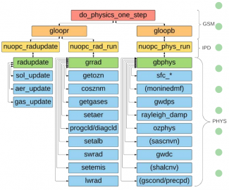
The schematic diagram representing the GFS Physics calling structure.

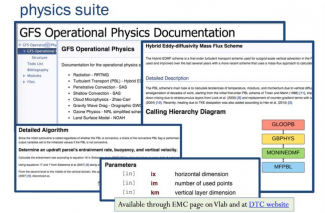
As part of its effort to set up a framework for a Common Community Physics Package (CCPP), the DTC’s Global Model Test Bed is documenting the Global Forecast System’s operational physics suite using “Doxygen” software.

Doxygen is [a] tool for generating documentation from popular programming languages include Python, Fortran, C, C++, IDL

This software parses specially formatted in-line comments and creates navigable and searchable web documents.

For the GFS physics suite, documentation is written within Fortran code, so is relatively easy to keep up-to-date as new developments are added to the model.

www.doxygen.org/

GFS Operational Physics Documentation


Software Release

Release of the MET version 6.0 Verification Package

Software Releases
Contributed by Staff

The MET development team at the DTC is pleased to announce the release of the MET version 6.0 verification package. It is available for download from the MET Users web page. The MET development team significantly enhanced the run-time performance of a number of tools, enhanced the data and file format capabilities, and added new capabilities for point observations, gridded analyses and tropical cyclone and probabilistic verification. Full details about the changes for this new version can be found in the release notes.

Executables for MET v6.0 are available on several high performance computing platforms (Yellowstone, Jet, Theia and WCOSS).  Paths, modules to load and the paths needed for these installs can be found at the bottom of the MET downloads page.  You simply need to symbolically link to the bin directory and copy the necessary config files to your working directory to use the available executables.

We hope that MET v6.0 enhances your model verification efforts. Please send any comments or questions to met_help@ucar.edu.