
During their recent project for the DTC Visitor Program, Michael Iacono and John Henderson of Verisk - Atmospheric and Environmental Research (AER) used the newly operational Hurricane Analysis and Forecasting System (HAFS) to evaluate the impact of an improved method to represent the sub-grid variability and vertical overlap of partial cloudiness in radiative transfer calculations on tropical cyclone predictions. This work was an extended application of their exponential (EXP) cloud overlap advancement that was adopted by NOAA in the 2018 operational Hurricane Weather Research and Forecasting (HWRF) model, and of their exponential-random (ER) method that NOAA adopted in the operational HWRF in 2020.
Clouds are a critical component of Earth’s climate. They strongly influence both the incoming solar (or shortwave) energy, which fuels the climate system, and the thermal (or longwave) energy that is emitted by the surface and partially escapes to space. Understanding the way that clouds absorb, emit, and scatter radiation is essential to modeling their role in Earth’s radiative processes effectively.
One limitation to simulating clouds and their radiative impact accurately is the challenge of representing their variability on scales smaller than the typical grid spacing of global atmospheric models (~10 km) and regional models such as HAFS (~2 km). Radiative transfer through sub-grid scale clouds depends on whether fractional clouds are vertically correlated, such as in tall thunderstorm clouds, or uncorrelated such as for randomly distributed polar clouds. This radiative process is also dependent on properly simulating cloud fraction and both the physical and optical properties of clouds.
Using the Rapid Radiative Transfer Model for Global Climate Models (RRTMG) radiation code in HAFS, the primary objective of this project was to establish whether any predictive benefit is gained by using EXP or ER. These methods have been shown to be more realistic relative to radar measurements within vertically deep clouds when compared with the older maximum-random (MR) method currently used in HAFS. The MR approach forces the clouds to be more vertically coherent through adjacent partly cloudy layers. EXP and ER relax this restriction by allowing the correlation to transition exponentially from maximum to random with vertical distance through the cloudy layers. A small adjustment is provided by a spatially dependent decorrelation length. ER adds a further randomization between cloudy layers separated by clear sky relative to EXP. The exponential treatments modestly increase total cloudiness and reduce shortwave radiation reaching the surface relative to MR cloud overlap.
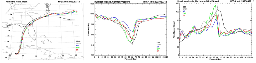
To assess this advancement in HAFS, hurricane predictions were performed by AER with the assistance of the DTC for multiple 2022 and 2023 tropical cyclones using MR, EXP, and ER cloud fraction overlap and a latitude-varying decorrelation length. The figure shows predictions of Hurricane Idalia track (left panel), central pressure (center panel), and maximum wind speed (right panel) for a forecast cycle initialized at 12:00 UTC on 27 August 2023. Observed “best-track” values are in black, predictions from the real-time operational HAFS-A are in gray, and predictions from a near-operational version of HAFS-A using MR, EXP, and ER cloud overlap are in blue, green, and red, respectively. Although the operational HAFS-A run also used MR cloud overlap, it applied the warm-start method for vortex initialization, which improved its prediction. The three forecasts performed by AER used cold-start initialization, and therefore are not directly comparable to the operational forecast. Although the track of Idalia was not very sensitive to the overlap method in this case, both measures of Idalia’s intensity show much greater sensitivity to cloud overlap, which suggests some predictive benefit of using the exponential approaches.
Our interactions with the DTC have been a rewarding opportunity to investigate new directions on this research topic, to work with two operational hurricane models, and to transition critical physics enhancements to NOAA operations. We expect to continue pursuing further research collaborations with the DTC and NOAA/EMC in the future.